Little Mesa Fire Update – September 20, 2023
Location: Approx. 15 miles west, southwest of Delta, CO, Dominguez Escalante National Conservation Area Discovered: July 31, 2023, 11:00 AM
Cause: Lightning
Estimated Size: 4,009 acres
Vegetation Type: Pinyon, Juniper, sagebrush, grass
Containment: 100%
Total Personnel: 4
Special Note: This will be the last update for the Little Mesa Fire, unless fire activity increases significantly.
Current Situation: The Little Mesa Fire reached 100% containment on Tuesday, September 19, 2023. Firefighters determined the perimeter is contained and will stop further fire spread under reasonable conditions. Smoke may be intermittently present from the interior while vegetation smolders. The fire is being managed by a confine and contain strategy using existing roads and natural barriers. View this video to understand how the Little Mesa Fire is being managed https://www.youtube.com/watch?v=QfTz-5SCcmk.
For updated information follow on these outlets:
Inciweb: https://inciweb.wildfire.gov/incident-information/coupd-little-mesa-fire
Facebook: @LittleMesaFire
Twitter: @SWD_Fire
Photo: Skyway Wildland Fire Module digging fire line. Credit: Little Mesa Fire
—
Little Mesa Fire Update – Friday, August 25, 2023
Location: Approx. 15 miles west, southwest of Delta, CO, Dominguez Escalante National Conservation Area
Discovered: July 31, 2023, 11:00 AM
Cause: Lightning
Estimated Size: 4,009 acres
Vegetation Type: Pinyon, Juniper, sagebrush, grass
Containment: 40%
Total Personnel: 25
Special Note: This will be the last daily update for the Little Mesa Fire, unless fire activity increases significantly. Firefighting personnel remain working on the fire and are prepared for quick response should fire conditions change in upcoming days.
Current Situation: Minimal fire activity was observed yesterday from recent rain; still, subsurface pockets of heat, stumps, and logs within the perimeter will continue to smolder until larger amounts of precipitation extinguish them or they burn themselves out. Firefighters continued to patrol and secure the fire edge while monitoring vegetation conditions for an opportunity to burn the southern lines along Black Point Road and Dry Mesa Road. However, the proper conditions never presented themselves; it was too humid and damp. Yesterday afternoon, light to moderate rain moved over the fire area and continued throughout the night.
In the forthcoming days, fire resources will continue to patrol the perimeter and be vigilant of changing fire conditions as the area begins to dry out next week. Firefighters will observe conditions looking for opportunities to burn the southern lines along Black Point Road and Dry Mesa Road to remove unburned vegetation between the fire perimeter and roads. Completing this burn and reducing available vegetation will tie the fire perimeter into the roads and assure that the fire will not cross the roads.
Weather: Widespread isolated showers and thunderstorms are forecasted in the morning increasing to a 50% chance of wetting rain by afternoon. The area could receive up to one half to one inch of rain. Temperatures will be in the 70’s with south winds 5 mph switching to west in the afternoon. Gusty and erratic winds are expected near thunderstorms in the afternoon.
Evacuations and Closures: No evacuations have been issued. Temporary road closures are in place in Delta County on Dry Mesa Road at the intersection with Escalante Rim Road and on USFS Dry Mesa Road at Sawmill Mesa Road junction. The GMUG National Forests issued a forest closure order for the area around the Little Mesa Fire. Public access to the closure area is limited. Visit
https://bit.ly/3YwXNz0 for more information.
Aviation Safety: Incident aircraft may be flying over the Little Mesa Fire air space. Fire aviation resources are flying at different altitudes and speeds. Unmanned aircraft systems (UAS) or drones must never fly near wildfires. Remember if you fly, we can’t!
—
Little Mesa Fire Update – Thursday, August 24, 2023
Location: Approx. 15 miles west, southwest of Delta, CO, Dominguez Escalante National Conservation Area
Discovered: July 31, 2023, 11:00 AM
Cause: Lightning
Estimated Size: 4,009 acres
Vegetation Type: Pinyon, Juniper, sagebrush, grass
Containment: 40%
Total Personnel: 25
Current Situation: After two weeks of hard work out on Dry Mesa, fire crews and supervisory staff will get replaced to allow them days off. Yesterday, new crews spent the day getting familiarized with the area and gaining situational awareness about hazards and safety concerns, taking turns so there were always firefighters watching for threats to the fireline. The area received sporadic localized showers, which was a limiting factor in the work that could be completed. When storms move through the area, the resulting lightning, slippery roads, and mud create hazards that force firefighters to take cover in vehicles or under tarps. The Multi Mission Aircraft was able to fly and map the perimeter yesterday. Infrared data showed an increase in acreage due to hand ignition operations on Tuesday to secure the Dry Mesa Road.
With more rain in the forecast through the weekend, crews will spend their time patrolling and monitoring the south side of the fire perimeter, where there is the most heat. After this surge of monsoonal moisture passes, they will have to reassess conditions on the ground. Residual heat is anticipated to remain within the fire area after these storms pass. The long-term goal is to increase containment by performing firing operations off of roads that have been identified as containment lines. By removing the available fuel between the remaining interior heat and the fire lines, confidence can be gained that the fire will not cross the line.
Weather: The remnants of Tropical Storm Harold will move through the region bringing widespread showers and thunderstorms. Look for periods of some gusty outflow winds, lightning, and some heavy rain from the strongest showers and storms. Scattered rain showers and isolated thunderstorms are expected in the morning, then rain showers and numerous thunderstorms in the afternoon with an 80% chance of wetting rain over the fire area. Temperatures will be in the high 70’s with south winds 5 to 10 mph switching to northwest in the afternoon.
Evacuations and Closures: No evacuations have been issued. Temporary road closures are in place in Delta County on Dry Mesa Road at the intersection with Escalante Rim Road and on USFS Dry Mesa Road at Sawmill Mesa Road junction. The GMUG National Forests issued a forest closure order for the area around the Little Mesa Fire. Public access to the closure area is limited. Visit
https://bit.ly/3YwXNz0 for more information.
Aviation Safety: Incident aircraft may be flying over the Little Mesa Fire air space. Fire aviation resources are flying at different altitudes and speeds. Unmanned aircraft systems (UAS) or drones must never fly near wildfires. Remember if you fly, we can’t!
—
Little Mesa Fire Update
Wednesday, August 23, 2023
Location: Approx. 15 miles west, southwest of Delta, CO, Dominguez Escalante National Conservation Area
Discovered: July 31, 2023, 11:00 AM
Estimated Size: 3,943 acres
egetation Type: Pinyon, Juniper, sagebrush, grass
Current Situation: Thanks to the hard work done by firefighters, the containment of Little Mesa Fire is now 40%. Like much of the region, the fire area was mostly cloudy yesterday, with some gusty winds and light rain. The southern area of the fire received about 1/10th inch of rain while the northern end was left without any measurable precipitation. Firefighters began extending the black (burned area) to tie in the previous day’s hand ignitions to Black Point Road but only progressed about 400 yards before they were interrupted by rain and high humidity. The rest of the day was spent continuing to mop up and cold-trail the fire edge, a tedious but necessary step in gaining containment on any fire.
Today, firefighters plan to make another attempt to tie in the black they created during the firing operation on Monday into the Black Point Road to the south.
Weather: Mostly sunny skies are expected until about noon today, with a chance of scattered showers and thunderstorms this afternoon into the evening. Highs are forecast to be in the upper 70’s in the fire area. Southwest winds 15-20 mph are expected this morning, with a shift to lighter southerly winds this afternoon.
Monsoonal moisture in the region will get an extra boost from former Tropical Storm Harold as it gets pulled into the southerly flow. This moisture will bring widespread showers and thunderstorms beginning this evening and lasting through the end of the week. These storms will be capable of producing heavy rain, gusty winds, and frequent lighting. Chances of wetting rain will be increased Thursday, Friday, and into Saturday.
Evacuations and Closures: No evacuations have been issued. Temporary road closures are in place in Delta County on Dry Mesa Road at the intersection with Escalante Rim Road and on USFS Dry Mesa Road at Sawmill Mesa Road junction. The GMUG National Forests issued a forest closure order for the area around the Little Mesa Fire. Public access to the closure area is limited. Visit
https://bit.ly/3YwXNz0 for more information.
Aviation Safety: Incident aircraft may be flying over the Little Mesa Fire air space. Fire aviation resources are flying at different altitudes and speeds. Unmanned aircraft systems (UAS) or drones must never fly near wildfires. Remember if you fly, we can’t!
Photo: Example of using road as fireline. Roads already are cleared to bare mineral soil, so they will not support fire growth. Firefighters often improve roads as fireline by cutting lower limbs off trees or cutting entire trees away from the road, or by firing off of the road to expand the area where there are no fuels for the fire to consume.
—
Little Mesa Fire Update
Tuesday, August 22, 2023
Location: Approx. 15 miles west, southwest of Delta, CO, Dominguez Escalante National Conservation Area
Discovered: July 31, 2023, 11:00 AM
Cause: Lightning
Estimated Size: 3,896 acres
Vegetation Type: Pinyon, Juniper, sagebrush, grass
Containment: 30%
Total Personnel: 35
NOTICE TO THE PUBLIC: Air operations may be conducted on the Little Mesa Fire. For your safety, please stay out of the Potholes Recreation Area. The helicopters are using this water source for fire suppression.
Current Situation: Conditions on the Little Mesa Fire were hot, dry and windy yesterday. Firefighters were forced to ignite along a two-track road on the southwestern end of the fire to protect the fire line against the winds produced by a storm cell that moved in from the southeast. All lines were held successfully. In order to prevent future use of the control line as a road, the excavator completed work on repairing the dozer lines that were created to suppress the fire. In addition, firefighters finished repairing fences damaged during fire suppression.
Today, firefighters will continue to cold-trail and mop up the fire edge. They also plan to tie in the black they created during yesterday’s firing operation into the Black Point Road to the south, if the weather is favorable.
Weather: Partly cloudy conditions are expected this morning with a chance of isolated showers this afternoon. Temperatures remain in the upper 80’s during the day with lows around 60 degrees at night. Southwest winds 10-15 mph are expected this afternoon with gusts up to 25 mph.
Today begins a trend of increasing moisture as a high pressure system to the east meets a low pressure system to the west over the area. The likelihood of thunderstorms and showers increases each day, with the greatest chance of widespread storms occurring on Thursday. Lightning, gusty outflow winds, and heavy rain are the greatest threats from any storm.
Evacuations and Closures: No evacuations have been issued. Temporary road closures are in place in Delta County on Dry Mesa Road at the intersection with Escalante Rim Road and on USFS Dry Mesa Road at Sawmill Mesa Road junction. The GMUG National Forests issued a forest closure order for the area around the Little Mesa Fire. Public access to the closure area is limited. Visit
https://bit.ly/3YwXNz0 for more information.
Aviation Safety: Incident aircraft may be flying over the Little Mesa Fire air space. Fire aviation resources are flying at different altitudes and speeds. Unmanned aircraft systems (UAS) or drones must never fly near wildfires. Remember if you fly, we can’t!
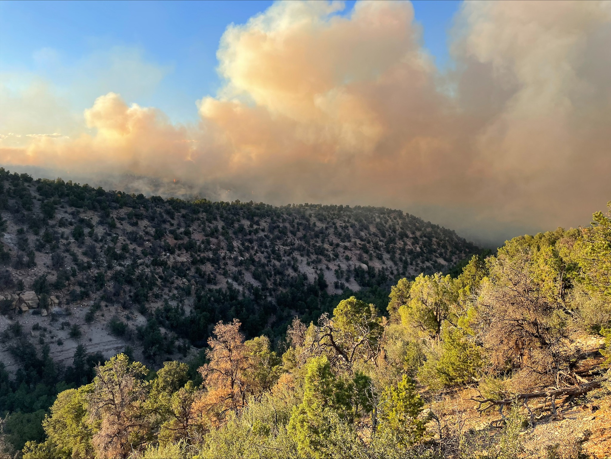
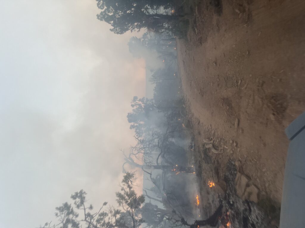
Photo: Skyway WFM firefighters dig hand line around a smoldering tree near the fire perimeter.
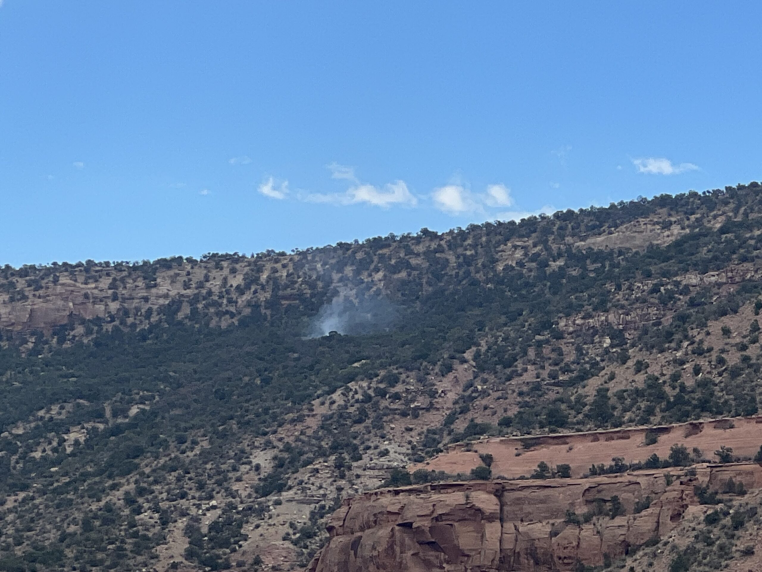
Today, the fire exhibited increased activity today as concentrations of fuel burned out. Fire stayed within containment lines but produced visible smoke in the area. The north end of the fire received rain today.
Little Mesa Fire Update – Monday, August 21, 2023
Location: Approx. 15 miles west, southwest of Delta, CO, Dominguez Escalante National Conservation Area
Discovered: July 31, 2023, 11:00 AM
Cause: Lightning
Estimated Size: 3,896 acres
Vegetation Type: Pinyon, Juniper, sagebrush, grass
Containment: 30%
Total Personnel: 35
NOTICE TO THE PUBLIC: Air operations may be conducted on the Little Mesa Fire. For your safety, please stay out of the Potholes Recreation Area. The helicopters are using this water source for fire suppression.
Current Situation: The fire saw no new growth yesterday. Firefighters made great progress in securing the fire edge, along with patrolling the area for threats to the fire line. With firefighter vigilance the fire held within the established containment areas throughout the day despite the windy hot conditions. Pockets of unburned vegetation deep in the fire’s interior actively burned and produced visible smoke. Lightning from previous days’ storms ignited many small fires in the region. Air resources and engines are being used to detect, locate, and contain these new starts.
Throughout the day firefighters will continue to patrol and extinguish heat along the fire perimeter. Smoke might continue to be seen as fire creeps into islands of unburned vegetation causing flare ups within the fire interior.
Weather: An increase of precipitation is expected for western Colorado. Though gusty winds will be widespread across the region, critical fire weather conditions are not expected due to the higher relative humidities today. Isolated showers and thunderstorms are possible in the afternoon. Mostly sunny today with temperatures in the high 80s and south winds 12 to 20 mph with gusts to 30 mph in the afternoon. Shower and thunderstorm coverage increases Tuesday and through the end of the week as monsoonal moisture and remnants of Tropical Storm Hilary filter into the region.
Evacuations and Closures: No evacuations have been issued. Temporary road closures are in place in Delta County on Dry Mesa Rd at the intersection with Escalante Rim Rd and on USFS Dry Mesa Rd at Sawmill Mesa Rd junction. The GMUG National Forests have issued a forest closure order for the area around the Little Mesa Fire. Public access to the closure area is limited. Visit
https://bit.ly/3YwXNz0 for more information.
Aviation Safety: Incident aircraft may be flying over the Little Mesa Fire air space. Fire aviation resources are flying at different altitudes and speeds. Unmanned aircraft systems (UAS) or drones must never fly near wildfires. Remember if you fly, we can’t!
For updated information follow on these outlets:
Facebook: @LittleMesaFire Twitter: @SWD_Fire
—
Little Mesa Fire Update – Sunday, August 20, 2023
Location: Approx. 15 miles west, southwest of Delta, CO, Dominguez Escalante National Conservation Area
Discovered: July 31, 2023, 11:00 AM
Cause: Lightning
Estimated Size: 3,896 acres
Vegetation Type: Pinyon, Juniper, sagebrush, grass
Containment: 30%
Total Personnel: 35
NOTICE TO THE PUBLIC: Air operations may be conducted on the Little Mesa Fire. For your safety, please stay out of the Potholes Recreation Area. The helicopters are using this water source for fire suppression.
Current Situation: Yesterday, firefighters accomplished a lot of great work patrolling and securing the fire perimeter. They focused on the southwest end off Dry Mesa Road to Black Point Road using a cold trailing technique, which means using the back of their bare hands to feel for heat. When heat is detected, they dig out the spot using their fire tool to cool it off. Water and dirt may also be used to assist. The excavator completed road repair and cleanup work, as well as digging holes for fence posts. The fire area did not receive any precipitation. Dry and windy conditions caused some single tree torching within the interior but did not threaten the fire line.
Today, firefighters will patrol and secure the perimeter by extinguishing any heat near the edge. Fire activity within the interior may pick up as pockets of unburned fuel flare up. Firefighters will remain alert as the area enters a warming and drying trend.
Weather: Tropical storm Hilary will cause an increase in the winds in the next couple of days. Mostly sunny today, with temperatures in the upper 80s. Conditions will dry out with increasing winds to 10 to 15 mph and gusts to 25 mph as dry air encompasses the area. Localized critical fire weather is possible, particularly in the lower valleys.
Warmer and drier temperatures and gusty afternoon winds will start to dry out vegetation, which will support easier fire spread in the dense vegetation within the interior.
Evacuations and Closures: No evacuations have been issued. Temporary road closures are in place in Delta County on Dry Mesa Rd at the intersection with Escalante Rim Rd and on USFS Dry Mesa Rd at Sawmill Mesa Rd junction. The GMUG National Forests have issued a forest closure order for the area around the Little Mesa Fire. Public access to the closure area is limited. Visit
https://bit.ly/3YwXNz0 for more information.
Aviation Safety: Incident aircraft may be flying over the Little Mesa Fire air space. Fire aviation resources are flying at different altitudes and speeds. Unmanned aircraft systems (UAS) or drones must never fly near wildfires. Remember if you fly, we can’t!
For updated information follow on these outlets:
Facebook: @LittleMesaFire Twitter: @SWD_Fire
—
Little Mesa Fire Update – Saturday, August 19, 2023
Location: Approx. 15 miles west, southwest of Delta, CO, Dominguez Escalante National Conservation Area
Discovered: July 31, 2023, 11:00 AM
Cause: Lightning
Estimated Size: 3,896 acres
Vegetation Type: Pinyon, Juniper, sagebrush, grass
Containment: 30%
Total Personnel: 35
NOTICE TO THE PUBLIC: Air operations maybe conducted on the Little Mesa Fire. For your safety, please stay out of the Potholes Recreation Area. The helicopters are using this water source for fire suppression.
Current Situation: Type 4 Incident Command took over the fire yesterday morning. Fire behavior was minimal after receiving precipitation earlier in the day with no growth, but due to better mapping the map shows an increase in acreage. The Wildland Fire Module flew their Unmanned Aircraft System (UAS) with infrared camera to detect heat along the southwest perimeter. Fire crews prepped for potential future burning from the southwest edge of the fire off Dry Mesa Road to Black Point Road. The excavator continued to perform cleanup operations, adding large vegetative material to reclose roads temporarily opened as containment lines and dispersing pockets of dead and down vegetation.
Fire behavior is expected to be reduced due to precipitation received overnight. Today, firefighters will patrol the fire perimeter, eliminating any heat along the edge and moving smoldering logs further into the interior. On the southwest end, firefighters will continue their prep work from Dry Mesa Road to Black Point Road. If weather conditions are conducive, firefighters may look at conducting hand ignitions along the prepped line. The excavator will complete road repair and cleanup work, as well as dig holes for fence posts.
Weather: Last night, deep tropical moisture was firmly in place around portions of western Colorado with widespread storm activity. Storms tracked on the fringes of the fire area producing abundant lightning with minimal to no precipitation. Drier air will begin to move in from the southeast today through Sunday, but widely scattered storm formation is still possible, with an increase in threat of gusty outflow winds. Winds will be from the south 7 to 12 mph, with temperatures in the mid-80s.
Evacuations and Closures: No evacuations have been issued. Temporary road closures are in place in Delta County on Dry Mesa Rd at the intersection with Escalante Rim Rd and on USFS Dry Mesa Rd at Sawmill Mesa Rd junction. The GMUG National Forests have issued a forest closure order for the area around the Little Mesa Fire. Public access to the closure area is limited. Visit
https://bit.ly/3YwXNz0 for more information.
Aviation Safety: Incident aircraft may be flying over the Little Mesa Fire air space. Fire aviation resources are flying at different altitudes and speeds. Unmanned aircraft systems (UAS) or drones must never fly near wildfires. Remember if you fly, we can’t!
For updated information follow on these outlets:
Facebook: @LittleMesaFire Twitter: @SWD_Fire
—
Little Mesa Fire Update – August 18, 2023
Location: Approx. 15 miles west, southwest of Delta, CO, Dominguez Escalante National Conservation Area
Discovered: July 31, 2023, 11:00 AM
Cause: Lightning
Estimated Size: 3,677 acres
Vegetation Type: Pinyon, Juniper, sagebrush, grass
Containment: 30%
Total Personnel: 63
NOTICE TO THE PUBLIC: Air operations are being conducted on the Little Mesa Fire. For your safety, please stay out of the Potholes Recreation Area. The helicopters are using this water source for fire suppression.
Current Situation: Gusty outflow winds from storms moving across the fire area yesterday kicked up the fire activity on the southwest end towards Dry Mesa Road. This activity stayed within the perimeter but generated more visible smoke in the area. The north end of the fire received some precipitation. It was a successful day for suppression repair, with firefighters able to finish repairing the handline along Tatum Ridge Road, seed the burn area, and fix fence line. The excavator completed work on the mastication lines and finished the majority of road repairs.
Today, the excavator will finish moving heavy natural material onto previously closed roads and dig holes for fence posts. Firefighters will patrol the fire edge and pull larger burning materials into the interior. If fire activity picks up again on the southwest end of the fire, firefighters may need to hand ignite off Dry Mesa Road to prevent the fire from crossing it. This morning, a Type 4 Incident Command assumed management responsibility for the Little Mesa Fire. This smaller organization will have ample fire resources along with availability of aircraft. The Type 3 Incident Organization would like to thank the fire resources for their hard work. Many will be released to allow for reassignment or days off to recuperate for the next assignment.
Weather: Deep subtropical moisture is in place across the entire western slope, which will set up for widespread showers and storms in the afternoon and evening. Moisture will continue to feed shower and thunderstorm activity near the fire through the end of the week. The threat of lightning and heavy rainfall will continue with the potential for a number of slow-moving storms. Gusty outflow winds will pose a lesser threat today. Winds will be from the southwest 10 to 15 mph with temperatures in the low 80s.
Evacuations and Closures: No evacuations have been issued. Temporary road closures are in place in Delta County on Dry Mesa Rd at the intersection with Escalante Rim Rd and on USFS Dry Mesa Rd at Sawmill Mesa Rd junction. The GMUG National Forests have issued a forest closure order for the area around the Little Mesa Fire. Public access to the closure area is limited. Visit
https://bit.ly/3YwXNz0 for more information.
Aviation Safety: Incident aircraft may be flying over the Little Mesa Fire air space. Fire aviation resources are flying at different altitudes and speeds. Unmanned aircraft systems (UAS) or drones must never fly near wildfires. Remember if you fly, we can’t!
For updated information follow on these outlets:
Facebook: @LittleMesaFire Twitter: @SWD_Fire
—
Little Mesa Fire Update – August 17, 2023
Location: Approx. 15 miles west, southwest of Delta, CO, Dominguez Escalante National Conservation Area
Discovered: July 31, 2023, 11:00 AM
Cause: Lightning
Estimated Size: 3,483 acres
Vegetation Type: Pinyon, Juniper, sagebrush, grass
Containment: 30%
Total Personnel: 65
NOTICE TO THE PUBLIC: Air operations are being conducted on the Little Mesa Fire. For your safety, please stay out of the Potholes Recreation Area. The helicopters are using this water source for fire suppression.
Current Situation: There was no new growth on the fire yesterday, but an increase in containment. The fire will be transitioning to a Type 4 Incident Friday morning. Yesterday, firefighters had another productive day using hand ignition to clean up unburned pockets of vegetation to secure the fire perimeter. The excavator was busy.
Suppression repair continues today with the excavator resuming work on mastication lines and roads. Firefighters on the northern end of the fire will repair hand line along the Tatum Ridge Road, fix fences around the guzzlers, and seed the burn area. A guzzler is a self-filling, constructed water collection and storage unit used to provide water to wildlife and livestock. Hand ignition operations will continue focusing on the southern end to clean up pockets of unburned vegetation.
Weather: A plume of moisture will continue to arc over western Colorado through the end of the week, with showers and thunderstorms becoming likely by Friday afternoon. Storms are expected to form on the ridge of the Uncompahgre by early afternoon and work their way towards the fire each afternoon. Temperatures will be in the 80s, with terrain-driven winds that increase to 10 to 15 mph in the afternoon, then switch to a southeast wind in the evening. Lightning and heavy rainfall will be the main threats, though small hail and gusty winds cannot be ruled out.
Evacuations and Closures: No evacuations have been issued. Temporary road closures are in place in Delta County on Dry Mesa Rd at the intersection with Escalante Rim Rd and on USFS Dry Mesa Rd at Sawmill Mesa Rd junction. The GMUG National Forests have issued a forest closure order for the area around the Little Mesa Fire. Public access to the closure area is limited. Visit
https://bit.ly/3YwXNz0 for more information.
Aviation Safety: Incident aircraft may be flying over the Little Mesa Fire air space. Fire aviation resources are flying at different altitudes and speeds. Unmanned aircraft systems (UAS) or drones must never fly near wildfires. The only UAS or drones able to fly are agency owned and operated, which have been assigned to work on the wildfire and have communication with air operations. Remember if you fly, we can’t!
For updated information follow on these outlets:
Facebook: @LittleMesaFire Twitter: @SWD_Fire
—
Little Mesa Fire Update for August 15, 2023
Location: Approx. 15 miles west, southwest of Delta, CO, Dominguez Escalante National Conservation Area
Discovered: July 31, 2023, 11:00 AM
Cause: Lightning
Estimated Size: 3,378 acres
Vegetation Type: Pinyon, Juniper, sagebrush, grass
Containment: 10%
Total Personnel: 92
NOTICE TO THE PUBLIC: Air operations are being conducted on the Little Mesa Fire. For your safety, please stay out of the Potholes Recreation Area. The helicopters are using this water source for fire suppression.
Current Situation: Yesterday, the southern end of the fire received low to moderate rain. Fire crews worked on mesa tops from Black Point to Dry Mesa cleaning up pockets of unburned vegetation. Today, firefighters on the northern end will work on cleaning up vegetation on the east side of Dry Mesa with hand ignition. The rest of the fire crews will hold and secure the fire edge. Throughout the Little Mesa Fire, there has been low intensity fire activity. The great work of the firefighters is reducing the chances of future high intensity fires that could have catastrophic effects.
The Little Mesa Fire was ignited by lightning. Natural fire starts can be a benefit for environmental resources by bringing fire back into a fire adapted ecosystem. The Little Mesa fire is helping to decompose dead and down trees left behind from the Ips beetle infestation approximately 20 years ago. Periodic fire stimulates new native plant growth by using the nutrients and minerals from the dead wood and plant matter being released back into the environment. This process also improves wildlife habitat by enhancing the desired vegetation and opening thick forest.
Weather: Subtropical moisture will remain in place through much of the week which will lead to the potential for showers and thunderstorms each day. Storms will favor the higher terrain to the south of the fire. The main threats from any storm will be lightning and erratic, gusty outflow winds. Temperatures will be in the low 80’s with winds out of the west, southwest at 10 to 15 mph in the afternoon.
Evacuations and Closures: No evacuations have been issued. Temporary road closures in Delta County on Dry Mesa Rd at the intersection with Escalante Rim Rd and on USFS Dry Mesa Rd at Sawmill Mesa Rd junction. The GMUG National Forests have issued a forest closure order for the area around the Little Mesa Fire.
Aviation Safety: Incident aircraft may be flying over the Little Mesa Fire air space. Fire aviation resources are flying at different altitudes and speeds. Unmanned aircraft systems (UAS) or drones must never fly near wildfires. The only UAS or drones able to fly are agency owned and operated, which have been assigned to work on the wildfire and have communication with air operations. Remember if you fly, we can’t!
For updated information follow on these outlets:
Facebook: @LittleMesaFire Twitter: @SWD_Fire
—
Little Mesa Fire Update
Monday, August 14, 2023
Location: Approx. 15 miles west, southwest of Delta, CO, Dominguez Escalante National Conservation Area
Discovered: July 31, 2023, 11:00 AM
Cause: Lightning
Estimated Size: 3,378 acres
Vegetation Type: Pinyon, Juniper, sagebrush, grass
Containment: 10%
Total Personnel: 84
NOTICE TO THE PUBLIC: Air operations are being conducted on the Little Mesa Fire. For your safety, please stay out of the Potholes Recreation Area. The helicopters are using this water source for fire suppression.
Current Situation: Yesterday, fire resources continue to mop up and secure the Tatum Ridge Road by moving smoldering logs farther into the interior. These actions assist in protecting values at risk and obtaining containment. Conditions were ideal to conduct helicopter aerial ignition operations to achieve resource benefits in a confine and contain suppression strategy from Black Point Road to Dry Mesa, Little Canyon, and the north end of Dry Mesa on Bureau of Land Management and Forest Service land. The helicopter covers more area, which contributed to the increase in acres. Aerial ignition operators use a plastic sphere dispenser (PSD) that look like ping pong balls. These balls are in a hopper that inject the balls with a chemical, then disperses them from the helicopter. The PSD then ignite and burn up once they reach the ground. This tool allows fire managers to target specific areas of vegetation to be burned.
Today fire crews will utilize the Unmanned Aerial System (UAS) drone and hand ignition to clean up unburned islands on mesas tops where there is heavy dead and down vegetation. Smoke will be visible in the afternoon as ignition operations begin.
Weather: Monsoon moisture is making its way into southwest Colorado bringing a chance of scattered showers and thunderstorms in the afternoon with slightly cooler temperatures. Winds will be terrain driven then become southwest with gust to 10 to 15 mph. Gusty and erratic winds are expected near showers and thunderstorms.
Evacuations and Closures: No evacuations have been issued. Temporary road closures in Delta County on Dry Mesa Rd at the intersection with Escalante Rim Rd and on USFS Dry Mesa Rd at Sawmill Mesa Rd junction. The GMUG National Forests have issued a forest closure order for the area around the Little Mesa Fire. Public access to the closure area is limited, visit
https://bit.ly/3YwXNz0 for more information.
Aviation Safety: Incident aircraft may be flying over the Little Mesa Fire air space. Fire aviation resources are flying at different altitudes and speeds. Unmanned aircraft systems (UAS) or drones must never fly near wildfires. The only UAS or drones able to fly are agency owned and operated, which have been assigned to work on the wildfire and have communication with air operations. Remember if you fly, we can’t!
For updated information follow on these outlets:
Facebook: @LittleMesaFire Twitter: @SWD_Fire
—
Little Mesa Fire Update
Sunday, August 13, 2023
Location: Approx. 15 miles west, southwest of Delta, CO, Dominguez Escalante National Conservation Area
Discovered: July 31, 2023, 11:00 AM
Cause: Lightning
Estimated Size: 776 acres
Vegetation Type: Pinyon, Juniper, sagebrush, grass
Containment: 10%
Total Personnel: 76
NOTICE TO THE PUBLIC: Air operations are being conducted on the Little Mesa Fire. For your safety, please stay out of the Potholes Recreation Area. The helicopters are using this water source for fire suppression.
Current Situation: Thanks to the hard work of fire crews, the fire is now 10% contained. Ignitions were performed yesterday by unmanned aircraft systems and by hand to clean up piles of unburnt dead and down fuel in the sage flats, and to strengthen the fire line east of Dry Mesa Rd near the Forest Service boundary. Another attempt will be made for aerial ignitions by helicopter today to secure the fire line along Black Ridge to Black Point. If unsuccessful, crews will continue with hand ignitions to meet objectives. A significant increase in smoke will be observed while ignition operations are performed.
Fire managers are utilizing a confine and contain suppression strategy on the mesa tops (Little Mesa, Dry Mesa, and Black Ridge Mesa) to achieve resource benefits while protecting identified values. Those values are firefighter and public safety, private lands, state lands, cultural sites, and threatened/endangered plants. The resource benefits include improved long-term wildlife habitat and restoration of more natural conditions to fire-dependent landscapes, which will reduce the future likelihood of large, catastrophic wildfires.
Weather: Monsoon moisture will keep relative humidities between 15-20%. Scattered showers and thunderstorms will stay mainly over higher terrain north of the fire. The potential for wetting rains will be low over the fire today. Gusty outflow winds and lightning are the primary concern with these storms.
Evacuations and Closures: No evacuations have been issued. Temporary road closures in Delta County on Dry Mesa Rd at the intersection with Escalante Rim Rd and on USFS Dry Mesa Rd at Sawmill Mesa Rd junction. The GMUG National Forests have issued a forest closure order for the area around the Little Mesa Fire. Public access to the closure area is limited, visit
https://bit.ly/3YwXNz0 for more information.
Aviation Safety: Incident aircraft may be flying over the Little Mesa Fire air space. Fire aviation resources are flying at different altitudes and speeds. Unmanned aircraft systems (UAS) or drones must never fly near wildfires. The only UAS or drones able to fly are agency owned and operated, which have been assigned to work on the wildfire and have communication with air operations. Remember if you fly, we can’t!
For updated information follow on these outlets:
Twitter: @SWD_Fire
Photo Credit: Phil Quigley, Skyway WFM
—
Little Mesa Fire Update
Saturday, August 12, 2023
Location: Approx. 15 miles west, southwest of Delta, CO, Dominguez Escalante National Conservation Area
Discovered: July 31, 2023, 11:00 AM
Cause: Lightning
Estimated Size: 642 acres
Vegetation Type: Pinyon, Juniper, sagebrush, grass
Containment: 0%
Total Personnel: 75
NOTICE TO THE PUBLIC: Air operations are being conducted on the Little Mesa Fire. For your safety, please stay out of the Potholes Recreation Area. The helicopters are using this water source for fire suppression.
Current Situation: Yesterday’s Multi-Mission Aircraft flight measured the fire at 642 acres. Resources continued cleaning up unburnt piles of dead and down along Tatum Ridge Rd to secure Escalante Canyon. They also “mopped up” hot spots along the road. Mopping up is the process of manually removing and extinguishing all sources of heat (such as smoldering logs or subsurface burning tree roots) within a certain proximity to the fire line, usually 100 to 300 feet. A fire’s edge cannot be considered contained until mop up is complete.
Conditions for aerial ignitions yesterday were not conducive until late in the day. Due to a short flight window, helicopter ignitions were postponed. Some ignitions were performed by UAS between Dry Mesa and Little Canyon to clean up unburnt pockets of fuel. Another attempt will be made at aerial ignitions today to achieve the goal of strengthening the fire line to the south and southwest edges of the fire perimeter. A significant increase in smoke will be observed while ignition operations are performed.
Weather: There continues to be a chance of rain over the fire area throughout the day and mostly cloudy conditions are expected. Light winds 8-13 mph are forecast out of the west.
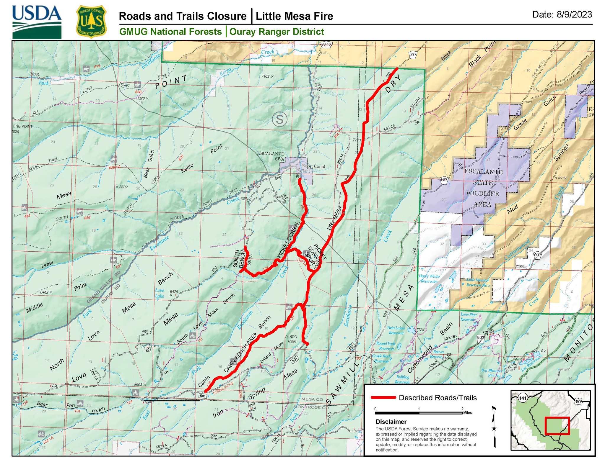
Evacuations and Closures: No evacuations have been issued. Temporary road closures in Delta County on Dry Mesa Rd at the intersection with Escalante Rim Rd and on USFS Dry Mesa Rd at Sawmill Mesa Rd junction. The Grand Mesa, Uncompahgre and Gunnison National Forests have issued a forest closure order for the area around the Little Mesa Fire. Public access to the closure area is limited, and includes National Forest System Road (NFSR) #502 – Dry Mesa road, NFSR #501.1A – South Bench road, National Forest System Trail (NFST) #102 – Picket Corral trail, NFST #102.1A – Picket Corral Spur trail and NFST #104 – Cabin Bench Area trail.
Aviation Safety: Incident aircraft may be flying over the Little Mesa Fire air space. Fire aviation resources are flying at different altitudes and speeds. Unmanned aircraft systems (UAS) or drones must never fly near wildfires. The only UAS or drones able to fly are agency owned and operated, which have been assigned to work on the wildfire and have communication with air operations. Remember if you fly, we can’t!
For updated information follow on these outlets:
—
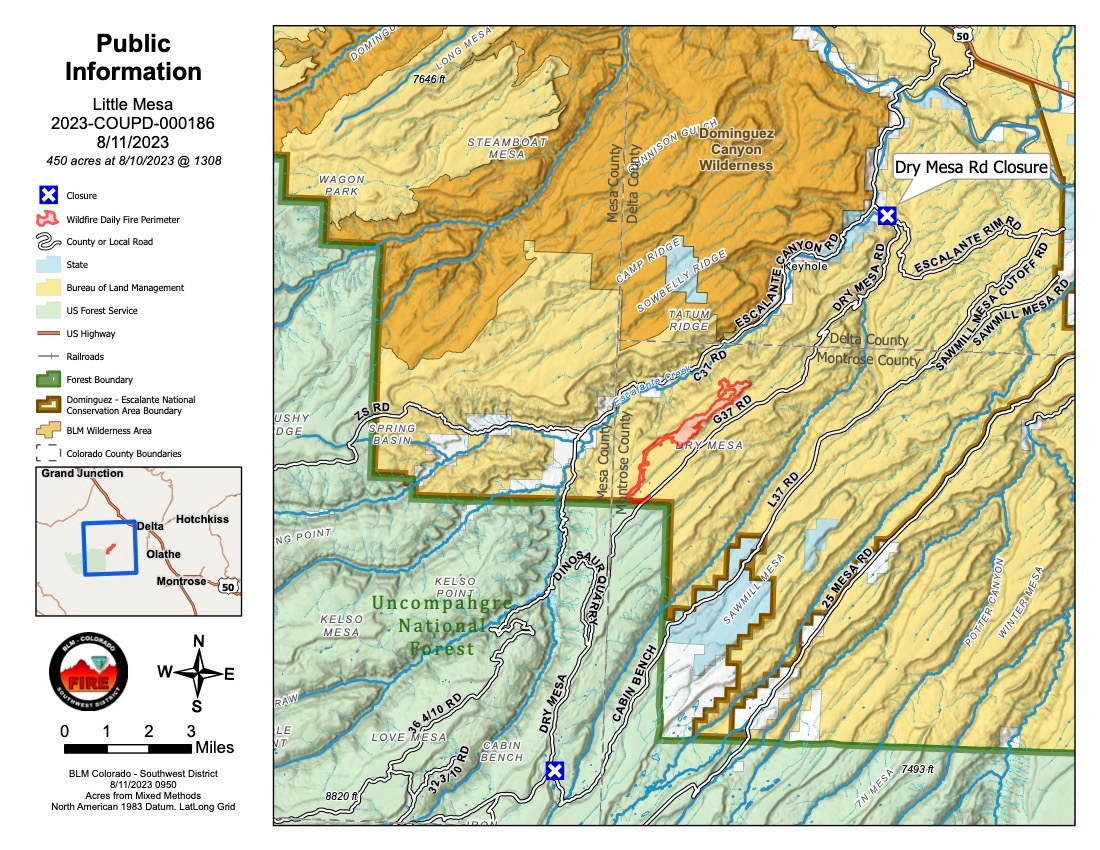
Little Mesa Fire Update
Friday, August 11, 2023
Location: Approx. 15 miles west, southwest of Delta, CO, Dominguez Escalante National Conservation Area
Discovered: July 31, 2023, 11:00 AM
Cause: Lightning
Estimated Size: 433 acres
Vegetation Type: Pinyon, Juniper, sagebrush, grass
Containment: 0%
Strategy: Full Suppression
Total Personnel: 76
NOTICE TO THE PUBLIC: Air operations are being conducted on the Little Mesa Fire. For your safety, please stay out of the Potholes Recreation Area. The helicopters are using this water source for fire suppression.
Current Situation: The fire area received very light rain last night but not enough to have a significant effect on fire behavior. Yesterday’s Multi-Mission Aircraft flight measured the fire at 433 acres. Firefighters spent yesterday cleaning up islands of unburnt fuel in Division A to secure Tatum Ridge Rd, which caused an increase in smoke put up from the fire area. Several spots were thrown into Little Canyon but crews were able to catch them before they spread. In Division Z, final scouting and prep work of Black Ridge to Black Point was completed and a plan was finalized for aerial ignitions to reinforce the line today.
Today’s plan is for firefighters in Div A to patrol Tatum Ridge Rd and continue to protect Escalante Canyon. In Div Z, crews will hold the fire line while aerial ignitions are performed to strengthen the fire line to the south and southeast, as conditions allow. This could cause a significant increase in smoke this afternoon into the evening.
Weather: Similar to yesterday’s forecast, the fire area has a chance of showers this evening into tonight. Winds out of the Southwest will push smoke towards Delta.
Evacuations and Closures: No evacuations have been issued. Temporary road closures in Delta County on Dry Mesa Rd at the intersection with Escalante Rim Rd and on USFS Dry Mesa Rd at Sawmill Mesa Rd junction. The Grand Mesa, Uncompahgre and Gunnison National Forests have issued a forest closure order for the area around the Little Mesa Fire. Public access to the closure area is limited, and includes National Forest System Road (NFSR) #502 – Dry Mesa road, NFSR #501.1A – South Bench road, National Forest System Trail (NFST) #102 – Picket Corral trail, NFST #102.1A – Picket Corral Spur trail and NFST #104 – Cabin Bench Area trail.
Aviation Safety: Incident aircraft may be flying over the Little Mesa Fire air space. Fire aviation resources are flying at different altitudes and speeds. Unmanned aircraft systems (UAS) or drones must never fly near wildfires. The only UAS or drones able to fly are agency owned and operated, which have been assigned to work on the wildfire and have communication with air operations. Remember if you fly, we can’t!
For updated information follow on these outlets:
Facebook: @LittleMesaFire Twitter: @SWD_Fire


—
The Grand Mesa, Uncompahgre and Gunnison National Forests have issued a forest closure order for the area around the
#LittleMesaFire. Public access to the closure area is limited, and includes National Forest System Road (NFSR) #502 – Dry Mesa road, NFSR #501.1A – South Bench road, National Forest System Trail (NFST) #102 – Picket Corral trail, NFST #102.1A – Picket Corral Spur trail and NFST #104 – Cabin Bench Area trail.
The public is asked to adhere to the closure for public health and safety of our fire personnel.
—
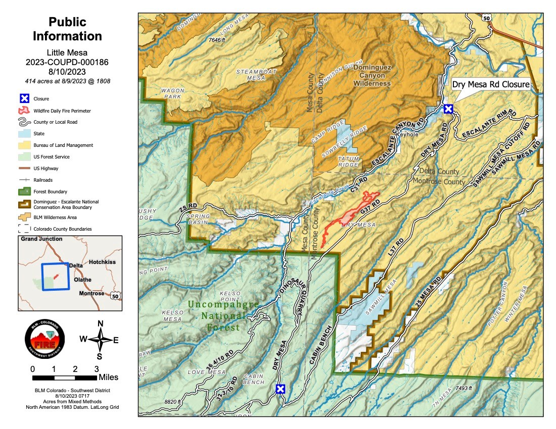
Thursday, August 10, 2023 @10 am
Little Mesa Fire Update
Location: Approx. 15 miles west, southwest of Delta, CO, Dominguez Escalante National Conservation Area
Jurisdiction: Bureau of Land Management
Discovered: July 31, 2023, 11:00 AM
Cause: Lightning
Estimated Size: 414 acres
Vegetation Type: Pinyon, Juniper, sagebrush, grass
Containment: 0%
Strategy: Full Suppression
Total Personnel: 65
NOTICE TO THE PUBLIC: Air operations are being conducted on the Little Mesa Fire. For your safety, please stay out of the Potholes Recreation Area. The helicopters are using this water source for fire suppression.
Current Situation: Management of the Little Mesa Fire has transitioned to a Type 3 team. The fire is estimated at 414 acres and has been divided into two Divisions for operational purposes. Yesterday, firefighters prepared the Dry Mesa Guzzler and two historical round pens in anticipation of fire passing through the area, and identified other range infrastructure in need of protection. Crews were able to hold the fire at Tatum Ridge Rd west of the fire, burn fuels along the road to strengthen the securement line of Escalante Canyon, and complete the road as an improved indirect fire line in advance of fire growth. The fire spotted across the Little Canyon to the east on to Dry Mesa but crews were able to catch and suppress the spots at under 1/10th of an acre. Crews scouted the Black Ridge to Black Point yesterday for areas of opportunity to create additional fire lines should the fire cross the primary containment lines along Dry Mesa Rd.
Today, firefighters on the west side, Division A, will work to secure any unburnt islands along Tatum Ridge Rd and continue to hold the fire along the road. In Division Z, to the east of the fire, crews will secure the Dry Mesa Rd by burning off fuels in advance of the fire. They will also identify areas where they can utilize drones to clean up interior pockets of unburnt fuel in Little Canyon. Forest Service and BLM resource specialists are scouting to identify areas of concern and prevent resource damage. Additional fire crews are en route to arrive this afternoon.
Weather: The forecast is showing a chance of showers today and tonight, with a greater chance of wetting rain over the fire area this evening. Winds out of the Southwest will be more mild than they have been but are still expected to push smoke towards Delta.
Evacuations and Closures: No evacuations have been issued. Temporary road closures in Delta County on Dry Mesa Rd at the intersection with Escalante Rim Rd in Escalante Canyon and on USFS Dry Mesa Rd at Sawmill Mesa Rd junction.
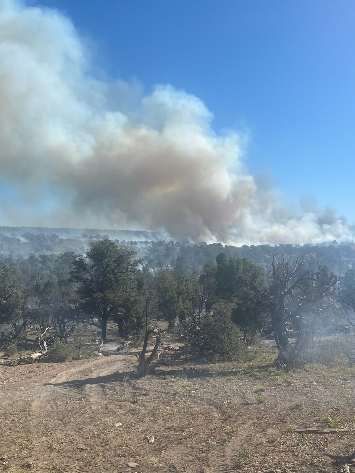
Smoke: Smoke is visible from surrounding areas and Highways 50, 550, 92, 65, 141 and C37 Road, especially in the afternoons. Go to
fire.airnow.gov or
colorado.gov/airquality/ to get updates on smoke conditions.
Aviation Safety: Aircraft may be used over the Little Mesa Fire air space. Fire aviation resources are flying at different altitudes and speeds. Unmanned aircraft systems (UAS) or drones must never fly near wildfires, as UAS are difficult to see and drone pilots have no way of communicating with firefighting aircraft. The only UAS or drones able to fly are agency owned and operated and have been assigned to work on the wildfire and have communication with air operations. Remember if you fly, we can’t!
For updated information follow on these outlets:
Facebook: @LittleMesaFire Twitter: @SWD_Fire
Little Mesa Fire Update
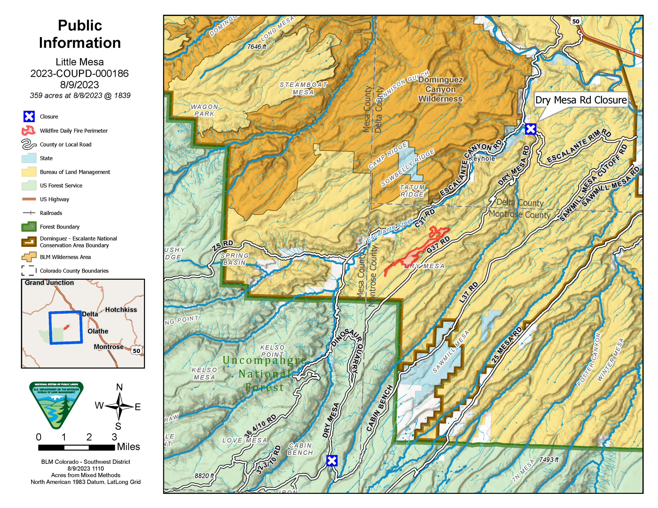
Wednesday, August 9, 2023
Location: Approx. 15 miles west, southwest of Delta, CO, Dominguez Escalante National Conservation Area Jurisdiction: Bureau of Land Management
Discovered: July 31, 2023, 11:00 AM
Cause: Lightning
Estimated Size: 359-acre
Vegetation Type: Pinyon pine, Juniper, sagebrush, and grass
Containment: 0%
Full Suppression Fire
Total Personnel: 65
NOTICE TO THE PUBLIC: Air operations are being conducted on the Little Mesa Fire. For your safety, please stay out of the Pothole Recreation Area. The helicopters will be using this water source to dip water from the potholes for fire suppression.
Current Situation: Last night the Little Mesa Fire was transferred to a Type 3 organization that will assume command of the fire. The fire is estimated at 359 acres by the Colorado Division of Fire Prevention and Control Multi-mission Aircraft infrared flight last night. Yesterday, firefighters prepped values at risk in the fire area and were able to hold the fire at natural barriers. The fire spotted across the little canyon and pushed up towards Dry Mesa Road, but no holding concerns once fire reached the sagebrush and slowed fire behavior.
Today, firefighters on the west side will hold fire along the Tatum Ridge Road to keep fire from going into Escalante Canyon. If weather conditions allow, firefighters will burn vegetation along their indirect lines to secure any up drainage runs that would impact indirect lines or Escalante Canyon. The firefighters on the east side will patrol Dry Mesa Road and continue prep on values at risk, Dry Mesa Guzzler and two historical round pins. They will scout further to the east along Black Ridge to Black Point.
Weather today should bring cooler temperatures and lighter winds that will decrease critical fire weather conditions. There is a change in weather starting on Thursday that may lead to increase in moisture and thunderstorms which could bring frequent lightning and gusty outflow winds each afternoon/evening through the weekend.
Evacuations and Closures: No evacuations have been issued. Temporary road closures in Delta County on Dry Mesa Road at the intersection with Escalante Rim Road in Escalante Canyon and on USFS Dry Mesa Road at Sawmill Mesa Road junction.
Smoke: Smoke is visible from surrounding areas and Highways 50, 550, 92, 65, 141 and C37 Road. Go to https://fire.airnow.gov to get updated smoke conditions in North America.
Aviation Safety: Aircraft may be used over the Little Mesa Fire air space. Fire aviation resources are flying at different altitudes and speeds. Pilots should exercise caution when flying near wildfires to keep everyone safe. Unmanned aircraft systems (UAS) or drones must never fly near wildfires, as UAS are difficult to see and drone pilots have no way of communicating with firefighting aircraft. The only UAS or drones able to fly are agency owned and operated and have been assigned to work on the wildfire and have communication with air operations. Remember if you fly, we can’t!
For updated information follow on these outlets:
Inciweb: https://inciweb.wildfire.gov/incident-information/coupd-little-mesa-fire
Facebook: @BLMMontroseFireUnit Twitter: @SWD_Fire
Little Mesa Fire
2023.littlemesa@firenet.gov
970-787-2993

For updated information follow our social media outlets:
Facebook: @BLMMontroseFireUnit
Twitter:@SWD_Fire
Montrose Interagency Dispatch website:www.wildwebe.net/?dc_name=COMTC
Location: Approx. 15 miles west, southwest of Delta, CO, Dominguez Escalante National Conservation Area
Jurisdiction:Bureau of Land Management
Discovered:July 31, 2023, 11:00 AM
Cause:Lightning
Vegetation Type: Pinyon pine, Juniper, sagebrush, and grass
Estimated Size:300-acre
Containment: 0%
Total Personnel: 60
Full Suppression Fire
NOTICE TO THE PUBLIC: Air operations are being conducted on the Little Mesa Fire. For your safety, please stay out of the Pothole Recreation Area. The helicopters will be using this water source to dip water from the potholes for fire suppression. The pilot needs to be focused on conducting this mission safely and is concerned for the public safety. Firefighters are overseeing the operation at the Potholes.
Current Situation: The Little Mesa Fire is a full suppression fire with a confine and contain strategy that provides for firefighter safety. Yesterday, red flag conditions continued to push the fire towards Dry Mesa which is the desired direction. Last night firefighters successfully fired out vegetation along the Tatum Ridge Road from the northwest fire edge towards the west to protect values at risk in Escalante Canyon. Fire resources were able to complete 90% of the indirect handline and anticipate completion today.
Another round of red flag conditions will be in effect from noon to 9 PM. The fire will receive stronger wind gusts today with hot and dry conditions. This combination will provide critical conditions to the area this afternoon. Wednesday will remain mostly dry with weaker winds.
Evacuations and Closures: No evacuations or closure orders have been issued.
Smoke: Smoke is visible from surrounding areas and Highway 50 and C37 Road. Go to https://fire.airnow.gov to get updated smoke conditions in North America.
Aviation Safety: Aircraft may be used over the Little Mesa Fire air space. Fire aviation resources are flying at different altitudes and speeds. Pilots should exercise caution when flying near wildfires to keep everyone safe. Unmanned aircraft systems (UAS) or drones must never fly near wildfires, as UAS are difficult to see and drone pilots have no way of communicating with firefighting aircraft. The only UAS or drones able to fly are agency owned and operated and have been assigned to work on the wildfire and have communication with air operations. Remember if you fly, we can’t!
Little Mesa Fire
2023.littlemesa@firenet.gov
—
Little Mesa Fire Update – Monday, August 7, 2023
Location: Approx. 15 miles west, southwest of Delta, CO, Dominguez Escalante National Conservation Area
Jurisdiction: Bureau of Land Management
Discovered: July 31, 2023, 11:00 AM
Cause: Lightning
Vegetation Type: Pinyon pine, Juniper, sagebrush, and grass
Estimated Size: 75-acre
Containment: 0%
NOTICE TO THE PUBLIC: Air operations are being conducted on the Little Mesa Fire. For your safety, please stay out of the Pothole Recreation Area. The helicopter is dipping water out of potholes for fire suppression. The pilot needs to be focused on conducting this mission safely and is concerned for the public safety. Firefighters are overseeing the operation at the Potholes.
Current Status: The Little Mesa Fire increased in size with the Red Flag conditions that occurred on Sunday. Firefighters made great progress constructing indirect hand line and working two masticators to complete 75% of the planned line. Low to moderate fire behavior occurred consuming ground vegetation and dead and down timber. Group tree torching and spotting is occurring in the pinyon pine and juniper forest during the hotter part of the day. Terrain and weather are pushing fire in the desired direction towards Dry Mesa. Little Mesa fire did cross the Tatum Road on Sunday. There are 60 fire personnel assigned to the fire along with the availability of aviation resources. Today, firefighters will work on completing hand and machine indirect line and work aviation resources as needed.
Red flag conditions will continue again today and be in effect from noon to 9 PM. The drying and warming trend continues resulting in stronger and gustier winds. This combination will provide critical conditions to the area this afternoon and into Tuesday.
Evacuations and Closures: No evacuations or closure orders have been issued.
Smoke: Smoke is visible from surrounding areas and Highway 50 and C37 Road. Go to
https://fire.airnow.gov to get updated smoke conditions in North America.
Aviation Safety: Aircraft may be used over the Little Mesa Fire air space. Fire aviation resources are flying at different altitudes and speeds. Pilots should exercise caution when flying near wildfires to keep everyone safe. Unmanned aircraft systems (UAS) or drones must never fly near wildfires, as UAS are difficult to see and drone pilots have no way of communicating with firefighting aircraft. The only UAS or drones able to fly are agency owned and operated and have been assigned to work on the wildfire and have communication with air operations. Remember if you fly, we can’t!
For updated information follow our social media outlets:
Facebook: @BLMMontroseFireUnit
Twitter: @SWD_Fire
—
Little Mesa Fire Update
Sunday, August 6, 2023
NOTICE TO THE PUBLIC: Air operations are being conducted on the Little Mesa Fire. For your safety, please stay out of the Pothole Recreation Area. The helicopter is dipping water out of potholes for fire suppression. The pilot needs to be focused on conducting this mission safely and is concerned for the public safety. Firefighters are overseeing the operation at the Potholes.
Current Status: The Little Mesa Fire is burning in the Dominguez Escalante National Conservation Area on public lands managed by the BLM Uncompahgre Field Office. Fire is located approximately 15 miles west, southwest of Delta, CO. This is a lightning caused fire in pinyon pine, juniper, sagebrush, and grass that is approximately 8 acres and 0% contained. Firefighters are on scene and working with aviation resources.
Red flag warning is in effect today from noon to 9 PM. The drying and warming trend continues today resulting in stronger and gustier winds. This combination will provide critical conditions to the area this afternoon. Near-critical fire weather conditions will likely occur on Monday and Tuesday as a disturbance moves across the northern US.
Smoke: Smoke is visible from surrounding areas and Highway 50 and C37 Road. Go to
https://fire.airnow.gov to get updated smoke conditions in North America.
Aviation Safety: Aircraft may be used over the Little Mesa Fire air space. Fire aviation resources are flying at different altitudes and speeds. Pilots should exercise caution when flying near wildfires to keep everyone safe. Unmanned aircraft systems (UAS) or drones must never fly near wildfires, as UAS are difficult to see and drone pilots have no way of communicating with firefighting aircraft. The only UAS or drones able to fly are agency owned and operated and have been assigned to work on the wildfire and have communication with air operations. Remember if you fly, we can’t!
For updated information follow our social media outlets:
Facebook: @BLMMontroseFireUnit
Twitter: @SWD_Fire
Little Mesa Fire Update
Sunday, August 6, 2023
Photo credit: NIFC from another wildfire
Little Mesa Fire Update, Wednesday, August 2, 2023
Location: Approx. 15 miles west, southwest of Delta, CO
Jurisdiction: Bureau of Land Management Discovered: July 31, 2023, 11:00 AM
Cause: Lightning Vegetation Type: Pinyon pine, Juniper, sagebrush, and grass
Estimated Size: 3 – 5-acre Containment: 0%
Current Status: The Little Mesa Fire is burning in the Dominguez Escalante National Conservation Area on public lands managed by the BLM Uncompahgre Field Office. The fire was reported on July 31, 2023, at 11:00 AM. Currently, there is one engine assigned, with additional resources ordered. During hotter parts of the day fire behavior may increase producing visible smoke in the area.
Planned Actions: Fire managers will evaluate and assess the safest tactics and strategies to manage the Little Mesa Fire for firefighters and public safety that may include using natural barriers for containment. Challenges include thunderstorms in the area, along with remote and rugged canyons, making access difficult for fire personnel.
Evacuations and Closures: No evacuations or closure orders have been issued.
Smoke: Smoke is visible from surrounding areas and Highway 50 and C37 Road. Go to https://fire.airnow.gov to get updated smoke conditions in North America.
Aviation Safety: Aircraft may be used over the Little Mesa Fire air space. Fire aviation resources are flying at different altitudes and speeds. Pilots should exercise caution when flying near wildfires to keep everyone safe. Unmanned aircraft systems (UAS) or drones must never fly near wildfires, as UAS are difficult to see and drone pilots have no way of communicating with firefighting aircraft. The only UAS or drones able to fly are agency owned and operated and have been assigned to work on the wildfire and have communication with air operations. Remember if you fly, we can’t!
Follow our social media outlets listed above to get the latest updates on the Little Mesa Fire if fire activity picks up.
For updated information follow our social media outlets:
Facebook: @BLMMontroseFireUnit
Twitter: @SWD_Fire
Montrose Interagency Dispatch website: www.wildwebe.net/?dc_name=COMTC