Skip to content

WEST SLOPE FIRE INFORMATION

Logo for West Slope Fire Info
  • Delta
  • Gunnison
  • Hinsdale
  • Mesa
  • Montrose
  • Ouray
  • San Miguel
  • BLM
  • Forest Service
  • DFPC
  • NPS
  • NewsExpand
    • BLM
    • Delta County
    • DFPC
    • Forest Service
    • Gunnison County
    • Hinsdale County
    • Mesa County
    • Montrose County
    • NPS News
    • Ouray County
    • San Miguel County
Logo for West Slope Fire Info

FIRE RESTRICTIONS are in effect

National Park Service

fire restrictions are in place.

LINKS

  • Curecanti National Recreation Area
  • Black Canyon of the Gunnison

MAPS

  • National Park Service Maps

Contact Information

NPS Black Canyon & Curecanti
Gunnison Field Office
(970) 641-2337 ext 205
102 Elk Creek
Gunnison, CO 81230


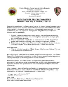
fire restrictions are currently in effect.
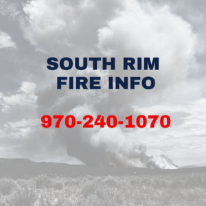
South Rim Fire Updates

South Rim Fire Updates

July 11, 2025July 11, 2025

Read More South Rim Fire UpdatesContinue

South Rim Fire Info

South Rim Fire Info

July 11, 2025July 11, 2025

Read More South Rim Fire InfoContinue

Highway 347 Closed at junction of 50

Highway 347 Closed at junction of 50

July 10, 2025July 10, 2025

Read More Highway 347 Closed at junction of 50Continue

Photo of the Black Canyon

Wildfires close Black Canyon of the Gunnison National Park – Black Canyon Of The Gunnison National Park (U.S. National Park Service)

July 10, 2025July 10, 2025

Read More Wildfires close Black Canyon of the Gunnison National Park – Black Canyon Of The Gunnison National Park (U.S. National Park Service)Continue

NOtice of Restriction Order

NOtice of Restriction Order

July 7, 2025July 7, 2025

Read More NOtice of Restriction OrderContinue

Photo of foreset

Public Land Agencies Offer Friendly Wildfire Safety Reminder for Labor Day Holiday

August 30, 2023August 30, 2023

Read More Public Land Agencies Offer Friendly Wildfire Safety Reminder for Labor Day HolidayContinue

SOCIAL

National Park Service Black Canyon

  • Facebook
  • Twitter
  • Instagram

National Park Service Curecanti National recreation area

  • Facebook
  • Twitter
  • Instagram
West Slope Fire Info logo

West Slope Fire is a partnership of regional agencies to provide fire restriction information on the West Slope of Colorado.

Parks and wildlife logo
National Park Service Logo
BLM SW Logo
Gunnison County Logo

Fire News

  • Fire News
  • Simms Fire
  • Upper Mailbox Fire
  • Cow Creek Fire
  • 416 Fire

Quick Links

  • About
  • Smoke
  • Accessibility

ACCESSIBILITY

Montrose County is committed to providing equitable access to our services and communications for all users. Our ongoing accessibility effort works towards being in line with the Web Content Accessibility Guidelines (WCAG) version 2.1, level AA criteria. These guidelines are designed to make technology accessible for all users, regardless of ability. We welcome comments on how to improve this website’s accessibility for users with disabilities and for requests for accommodations to any Montrose County services. If you are an individual with a disability and want to request a reasonable accommodation to any information and communication technology, or to report inaccessible content, please contact us. Montrose County will respond to your request within 3 business days.
Phone: 970-249-7755 option 7
Email: accessibility@montrosecounty.net

© 2025 West Slope Fire Info

Facebook Twitter
  • Delta
  • Gunnison
  • Hinsdale
  • Mesa
  • Montrose
  • Ouray
  • San Miguel
  • BLM
  • Forest Service
  • DFPC
  • NPS
  • News
    • BLM
    • Delta County
    • DFPC
    • Forest Service
    • Gunnison County
    • Hinsdale County
    • Mesa County
    • Montrose County
    • NPS News
    • Ouray County
    • San Miguel County
Search