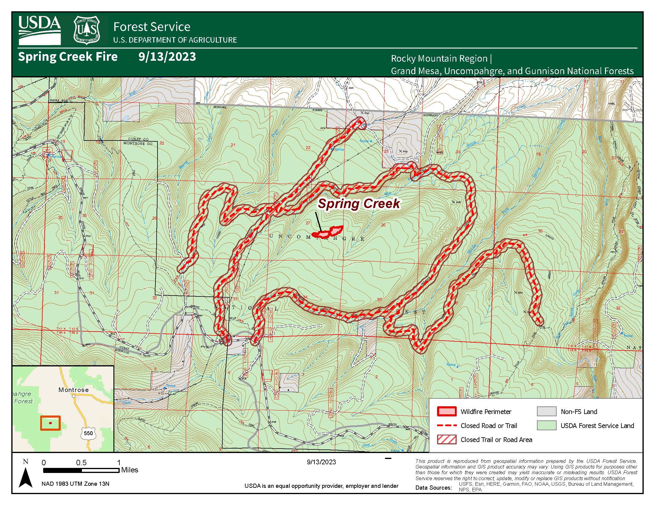
FINAL #Update -Sept 15, 2023
Location: East of Divide road, North of Spring Creek Canyon. The fire is approximately 15 miles southwest of Montrose, Colorado.
Size: Approximately 16 acres
Behavior: Creeping and smoldering with isolated tree torching
Cause: Under Investigation
Containment: 80%
Threatened Structures: 0
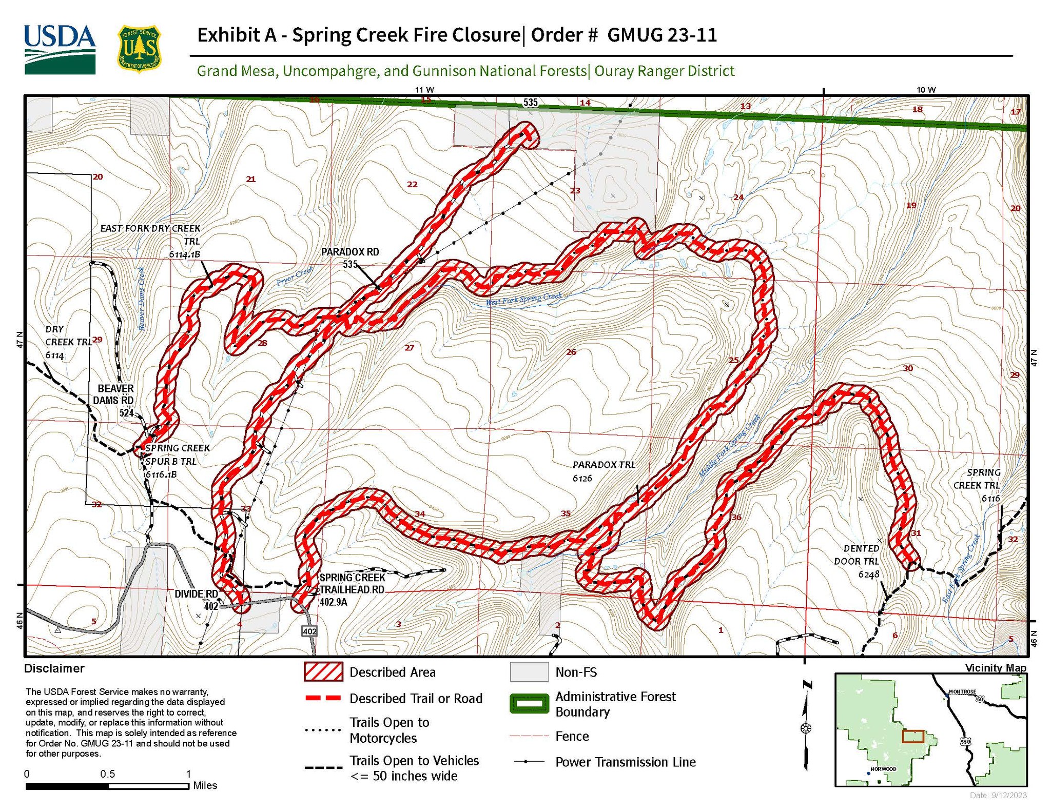
Closures: As of Friday, September 15 at 6 p.m., all closures due to the Spring Creek Fire have been lifted. Those lifted closures are for the following: National Forest System Roads (NFSR) #535 – Paradox road, NFSR #402.9A – Spring Creek Trailhead road, National Forest System Trail (NFST) #116 – Spring Creek Trail (from Dented Door to Paradox), NFST #126 – Paradox Trail and NFST #114.1B – East Fork of Dry Creek Trail
The Spring Creek Fire received additional precipitation overnight and containment remains at 80%. With the increased precipitation and reduction in fire behavior, all road closures are lifted as of 6 p.m. today, Friday, September 15. For those traveling into the wilderness this weekend, please remember to be prepared for all weather conditions and to recreate responsibly.
Additional firefighting resources have been released back to their home units, with two fire suppression module teams and one engine remaining on the fire at this time. These firefighting resources will continue to monitor conditions and address any additional needs. If you are recreating in the area, please be aware of firefighting personnel and practice caution on roads and trails.
This will be the final update for the Spring Creek Fire unless conditions change.
For additional information, please visit the links listed below.
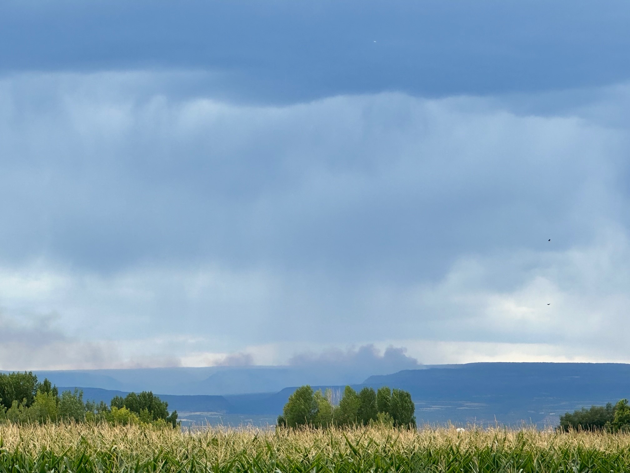
Weather & Fuel Conditions: The fire area continues to see a potential for increased moisture into the weekend. Winds will remain low at 10 mph, with nighttime temperatures in the mid-40s. Smoke may be visible in the Montrose, Ridgway and Delta communities. For more information on how wildfire smoke may affect your health, please visit https://www.colorado.gov/pacific/cdphe/wood-smoke-and-health.
For additional and continuing information:
GMUG National Forests Fire Information hotline: (970) 874-6602
Spring Creek Fire Inciweb: https://inciweb.nwcg.gov/incident…/cogmf-spring-creek
West Slope Fire Information website: www.WestSlopeFireInfo.com
GMUG Fire Info Facebook: https://www.facebook.com/GMUGFireInfo
Twitter: https://twitter.com/GMUG_NF
—
Location: East of Divide road, North of Spring Creek Canyon. The fire is approximately 15 miles southwest of Montrose, Colorado.
Size: Approximately 16 acres
Behavior: Creeping and smoldering with isolated tree torching
Cause: Under Investigation
Containment: 50%
Threatened Structures: 0
Closures: National Forest System Roads (NFSR) #535 – Paradox road, NFSR #402.9A – Spring Creek Trailhead road, National Forest System Trail (NFST) #116 – Spring Creek Trail (from Dented Door to Paradox), NFST #126 – Paradox Trail and NFST #114.1B – East Fork of Dry Creek Trail
The Spring Creek Fire received light precipitation last night; additional rainfall is expected today. The fire remains at 16 acres with 50% containment. Dozers have completed their work creating a containment line around the fire and firefighters are expected to complete additional containment work today.
This will be the final morning update for the Spring Creek Fire unless conditions change. We will continue to provide evening updates.
Weather & Fuel Conditions: Over the next several days, the fire area will continue to see a potential for increased moisture, primarily in the afternoon and later into the evening. Winds will remain low at 10 mph, with nighttime temperatures in the mid-40s. Smoke may be visible in the Montrose, Ridgway and Delta communities. For more information on how wildfire smoke may affect your health, please visit https://www.colorado.gov/pacific/cdphe/wood-smoke-and-health.
Montrose, Colorado, Sept. 13, 2023
Location: East of Divide road, North of Spring Creek Canyon. The fire is approximately 15 miles southwest of Montrose, Colorado.
Size: Approximately 16 acres
Behavior: Creeping and smoldering and isolated torching
Cause: Unknown–under Investigation
Jurisdiction: USFS
Containment: 50%
Threatened Structures: 0
Closures: National Forest System Roads (NFSR) #535 – Paradox road, NFSR #402.9A – Spring Creek Trailhead road, National Forest System Trail (NFST) #116 – Spring Creek Trail (from Dented Door to Paradox), NFST #126 – Paradox Trail and NFST #114.1B – East Fork of Dry Creek Trail
The Spring Creek Fire saw no growth yesterday, and containment of the fire increased to 50 percent. Favorable weather conditions and heavy precipitation decreased fire behavior while fire crews maintained their patrolling and monitoring of the fire along containment lines.
Today, firefighters will patrol and extinguish heat along the fire perimeter. They will use a cold trailing technique, which means using the back of their bare hands to feel for heat. When heat is detected, they dig out the spot using their fire tool to cool it off. Water and dirt may also be used to assist.
The following Forest Service road and trail closures are in effect, National Forest System Road (NFSR) #535 – Paradox road, NFSR #402.9A – Spring Creek Trailhead road, National Forest System Trail (NFST) #116 – Spring Creek Trail (from Dented Door to Paradox), NFST #126 – Paradox Trail and NFST #114.1B – East Fork of Dry Creek Trail.
Resources on scene include one Type 2 Helicopter, one water tender, one Type 4 and two Type 6 engines, three fire modules and one 20 person hand crew. Firefighter and public safety are the priorities for this incident. In the interest of public safety, fire officials ask visitors to be aware of fire traffic and avoid the area.
Weather & Fuel Conditions: The forecast remains the same for the next several days. The fire area will continue to see a potential for increased moisture, primarily in the afternoon and later into the evening. Winds will remain low at 10 mph, with nighttime temperatures in the mid-40s. Smoke may be visible in the Montrose, Ridgway and Delta communities. For more information on how wildfire smoke may affect your health, please visit https://www.colorado.gov/pacific/cdphe/wood-smoke-and-health.
—
The #GMUG announced a series of road and trail closures in response to the Spring Creek Fire. The fire was reported on the Uncompahgre National Forest, approximately 15 miles southwest of Montrose, Colorado, Sept. 10.
Due to the fire’s activity on National Forest System lands, the following closures will be enacted immediately:
National Forest System Roads (NFSR) #535–Paradox road, NFSR #402.9A–Spring Creek Trailhead road, National Forest System Trail (NFST) #116–Spring Creek Trail (from Dented Door to Paradox), NFST #126–Paradox Trail and NFST #114.1B–East Fork of Dry Creek Trail.
This Forest Service closure is being enacted for public and firefighter safety and will allow fire crews to focus on suppression efforts. The public is asked to adhere to this closure and pay close attention to all signage.
For questions concerning this emergency closure, please call the Ouray Ranger District (970) 240-5300.
—
091223 Update:
Size: Approximately 16 acres
Behavior: Creeping and smoldering with some isolated tree torching
Cause: Unknown–under Investigation
Jurisdiction: USFS
Containment: 20%
Threatened Structures: 0
Closures: National Forest System Roads (NFSR) #535 – Paradox road, NFSR #402.9A – Spring Creek Trailhead road, National Forest System Trail (NFST) #116 – Spring Creek Trail (from Dented Door to Paradox), NFST #126 – Paradox Trail and NFST #114.1B – East Fork of Dry Creek Trail
The Spring Creek Fire showed no new growth yesterday and is now 20% contained. No structures are threatened. Fire behavior for yesterday’s operational period included isolated tree torching with short-distance spotting in spruce, fir and aspen with heavy dead and down timber. The fire module crews worked on catching spot fires and cutting down hazard trees. Dozers worked steadily to put a containment line around the fire. Today’s expected fire behavior includes creeping and smoldering with some isolated tree torching.
Forest Service road and trail closures were implemented yesterday. The following closures are in effect, National Forest System Road (NFSR) #535 – Paradox road, NFSR #402.9A – Spring Creek Trailhead road, National Forest System Trail (NFST) #116 – Spring Creek Trail (from Dented Door to Paradox), NFST #126 – Paradox Trail and NFST #114.1B – East Fork of Dry Creek Trail.
Resources on scene include one Type 2 Helicopter, two dozers, one Type 4 and two Type 6 engines, three fire modules and one 20 person hand crew. Firefighter and public safety are the priorities for this incident. In the interest of public safety, fire officials ask visitors to be aware of fire traffic and avoid the area.
Weather & Fuel Conditions: Over the next several days, the fire area will continue to see a potential for increased moisture, primarily in the afternoon and later into the evening. Winds will remain low at 10 mph, with nighttime temperatures in the mid-40s. Smoke may be visible in the Montrose, Ridgway and Delta communities. For more information on how wildfire smoke may affect your health, please visit https://www.colorado.gov/pacific/cdphe/wood-smoke-and-health.
For additional information:
GMUG National Forests Fire Information hotline: (970) 874-6602
Spring Creek Fire Inciweb: https://inciweb.nwcg.gov/incident…/cogmf-spring-creek
West Slope Fire Information website: www.WestSlopeFireInfo.com
GMUG Fire Info Facebook: https://www.facebook.com/GMUGFireInfo
Twitter: https://twitter.com/GMUG_NF
#GMUGFireInfo#2023fireyear
Photo credits: Tony Holguin
Photo one-single tree on fire
Photo two-Spring Creek Fire smoke in the distance
Montrose County Sheriff’s Office
Ouray County Sheriff’s Office
—
091123 Update: The fire size was updated to approximately 16 acres after a Multimission Aircraft infrared flight at 11:30 a.m. Fire behavior is currently group tree torching with short-distance spotting in spruce, fir and aspen forest with heavy dead and down timber.
The following closures are in effect, National Forest System Road (NFSR) #535 – Paradox road, NFSR #402.9A – Spring Creek Trailhead road, National Forest System Trail (NFST) #116 – Spring Creek Trail (from Dented Door to Paradox), NFST #126 – Paradox Trail and NFST #114.1B – East Fork of Dry Creek Trail.
Weather & Fuel Conditions: Over the next several days, the fire area will see a potential for increased moisture, primarily in the afternoon and later into the evening. Winds remain low at 10 mph, and nighttime temperature lows remain in the mid-40s.
The fire is zero percent contained as of 11:30 a.m. No structures are threatened. Resources on scene include one Type 2 Helicopter, two dozers, one Type 4 and two Type 6 engines, and two fire modules. Firefighter and public safety are the priorities for this incident. In the interest of public safety, fire officials ask visitors to be aware of fire traffic and avoid the area. Please do not call 911.
Spring Creek Fire is now on Inciweb: https://inciweb.nwcg.gov/incident…/cogmf-spring-creek
—-
At approximately 3:44 p.m. Sunday, Sept.10, the Spring Creek Fire was reported on the Uncompahgre National Forest, approximately 15 miles southwest of Montrose, Colorado. The fire is approximately 20 acres with high spread potential and active fire behavior. It is zero percent contained. One engine and one Type 2 Helicopter are on scene, with three engines and two large air tankers en route. Firefighter and public safety are the priorities for this incident. Please do not call 911. All updates will be posted to the GMUG Fire Info Facebook page.