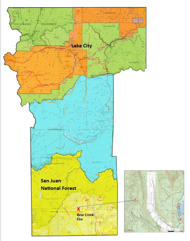
Bear Creek Fire Update for August 13th
Bear Creek Fire start date:
August 1, 2023
Mosca Fire start date:
August 7, 2023
Location: 23 miles Northwest of Pagosa Springs, Colorado
Cause: Lightning
Incident Commander: Jay Kurth
Management Team: NIMO Team 1
Management: Suppression
Fire size today:
Bear: 394 acres
Mosca: 7 acres
Containment: 0%
Personnel: 86
Evacuation Information:
Weminuche Valley is under pre-evacuation notice. Local residents should follow incident information and updates.
Closures:
Fire area closure – see Inciweb
Cloman Park in Pagosa Springs
Latest Smoke Outlook:
INCIDENT OBJECTIVES:
Highest priority: Firefighter and Public safety.
Protect private lands within the Weminuche Creek drainages, critical infrastructure including powerlines and gas utility lines, natural resources, cultural and historic sites, and recreation assets.
Wetting rains, cloudy weather and cooler temperatures assisted with slowing fire movement. The aspen stands to the east and south of the fire continued to slow fire growth, as they are less susceptible to fire spread. Firefighters have been unable to directly engage due to the dangerous loading of standing and down dead trees. While fire fighters are prepared for the fire to back down to the Weminuche Valley, significant fire growth is not expected today. The potential for spread remains in Bear Creek towards the Little Sand and Shaw Creek trails. Structure protection groups are in place and are assessing additional structures as well as monitoring the fire from the meadow.
The Mosca Fire grew slightly to 7 acres, burning in heavy down fuels and is headed toward a large aspen stand. The fire is burning in a remote area northwest of Bear Creek near Slide Mountain in difficult terrain.
YESTERDAY’S ACCOMPLISHMENTS:
Fire managers continued to use two masticators on the Mosca Road to the south of the fire to reduce fuels and to create a contingency line if that is needed.
Crews in the Weminuche Valley area assessed risk level to private land/structures and developed and implemented structure protection plans.
Local ground-fire resources continued to directly monitor fire growth and directional spread. These observations are critical to assessing the probability of success of the current incident strategy being achieved.
TODAY’S PLAN:
Continue fuels mitigation along the Mosca Road corridor with masticators.
Operational supervisors will continue scouting indirect control opportunities to the south along the Mosca Road, connecting that into the Weminuche Valley.
Continue to collaboratively develop Management Action Points (MAP) with cooperators and stakeholders. MAPs are clearly specified incident conditions that, when reached, prompt a predefined fire management action or trigger the implementation of new strategies/tactics.
Pike hotshots will be flown into the Mosca fire to assess the fire and begin to cut an access trail.
WEATHER:
The weather trend includes chances of rain showers and stable temperatures due to mostly cloudy skies. Additional moisture is temporarily predicted to move into the region on Monday.
Bear Creek and Mosca Fires Inciweb page: https://tinyurl.com/mrx4pp27
—
Bear Creek Fire in Southern Hinsdale County
Thursday, August 10, 2023
2:30 p.m.
The Bear Creek Fire is burning in thick forests in southern Hinsdale County, approximately 2.5 miles west of the Weminuche Valley and 23 miles northwest of Pagosa Springs. The fire is located approximately 32 miles south of Lake City in the San Juan National Forest. The fire currently is zero percent contained.
The fire has grown to approximately 330 acres since its discovery August 1st. Fire suppression crews monitored the fire from its start on August 1 with very little progression. With a turn in the weather that brought high winds and dry conditions, the fire began to grow. Firefighters have been unable to directly engage due to the dangerous loading of dead timber and very difficult terrain in the area. Fire resources remain in the immediate area and are actively monitoring progression of the fire with aircraft flying over twice a day. Fire fighters are prepared for when the fire backs down to the Weminuche Valley to begin suppression operations.
According to Hinsdale County Emergency Manager Phil Graham, currently aspen stands in the area are holding up well and slowing the fire spread toward private land. Fire behavior was moderated yesterday due to cloud cover and higher relative humidity.
Private property residents in the immediate area have been personally contacted by Archuleta County Sheriff Office and San Juan National Forest officers. Hinsdale County Sheriff Chris Kambish instituted a pre-evacuation notice for residents in the fire area on Wednesday, August 9, as the fire was progressing towards a ranch and other private property. No evacuation notification has been implemented at this time. Several Forest Service Trails in the area have been closed in response to fire activity.
According to Forest Service personnel, firefighter and public safety is the highest priority of all phases of the Bear Creek incident, followed by protection of private property and structures. There are currently 103 firefighting personnel on scene. Forest Service resources are currently working to protect structures on private property, using protective aluminized wrap and other measures.
The Bear Creek Fire has been described as a long-term incident, which most likely will be allowed to continue to burn in the forests until the fire ends naturally. Incident management will continue to be present in the area for the duration of the fire to monitor activity, especially near private property and structures.
Additional fires are burning in the San Juan National Forest in Archuleta County south of Hinsdale, including the Quartz Ridge Fire, which is burning approximately three miles into the South San Juan Wilderness. This fire has grown to 1225 acres since its discovery August 5th. Its smoke column is visible from Pagosa Springs and the surrounding area.
Specific information on the Bear Creek Fire can be found at https://inciweb.nwcg.gov/incident…/cosjf-bear-creek-fire.