#LowlineFire#Update – Wednesday, October 11, 2023
Size: 1999 Acres
Cause: Lightning
Containment: 55%
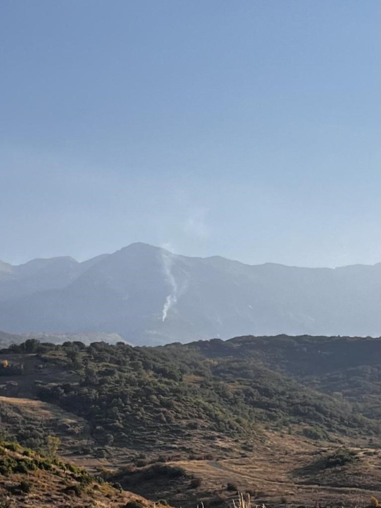
The Lowline Fire continues to creep and smolder along the southern and western edges, with the most activity north of Mill Creek and in the Squirrel Creek Drainage.
Smoke will continue to be visible from County road 730 and Ohio Creek and will likely persist until the area receives extensive precipitation. For more information on how wildfire fire smoke may affect your health, please visit https://www.colorado.gov/pacific/cdphe/wood-smoke-and-health.
In the interest of public safety, area closures will remain in effect through December 31, 2023, to ensure public and firefighter safety. For the complete closure order: https://www.fs.usda.gov/…/FSE_DOCUMENTS/fseprd1129908.pdf
For Lowline Fire update information, contact the Gunnison Ranger District: (970) 641-0471.
Sept. 21, 2023
Location: 14 miles north-northeast of Gunnison, Colorado, 11 miles southwest of Crested Butte, Colorado. Located on a ridge at 9400 ft elevation between Squirrel and Mill Creeks, 3.5 miles west of County Road 730, Ohio Pass Road.
Size: 1999 Acres
Cause: Lightning
Jurisdiction: USFS
Containment: 55%
The Lowline Fire continues to hold on the ridgeline between Squirrel Creek and Mill Creek drainages and along Middle Creek. Recent aerial mapping of the Lowline Fire indicates that the fire is now at 1999 acres, with some growth occurring along the western edge of the fire toward the wilderness area. Smoke continues to be visible from County Road 730 and Ohio Creek and will likely persist until the area receives a season-ending weather event.
Firefighters continue to monitor fire activity and remain prepared to take action should fire activity change. Residents can expect structure protection infrastructure such as sprinkler systems, pumps and water storage tanks to remain in the area until a season-ending weather event occurs.
The Lowline Fire is a long-duration wildfire event that is currently being administered under a “confine and contain” management strategy. Using this strategy, firefighters concentrate their fire suppression and containment efforts around the values at risk to the north, east and south of the Lowline Fire. On the western edge of this fire, the goal is to confine fire growth toward the wilderness boundary, where fire can be helpfully utilized toward forest health and future fire suppression needs. This management strategy is also a safer and more effective use of firefighting personnel, as the western area of the Lowline Fire presents a significant safety risk to firefighters due to heavy amounts of dead and downed trees. Firefighter and public safety remain our priorities.
In the interest of public safety, area closures remain in effect and are expected to remain in place until a season-ending weather event occurs in the fire area. For the full closure order: https://www.fs.usda.gov/…/FSE_DOCUMENTS/fseprd1129908.pdf
All evacuation notices have been lifted for the Lowline Fire. However, the area along Mill Creek and County Road 727 remains in pre-evacuation status. Area residents should remain informed of evacuation and pre-evacuation status as determined by Gunnison County. For Gunnison County evacuation information: https://www.gunnisoncounty.org/852/Wildfire-Information
For Lowline Fire update information, contact the Gunnison Ranger District: (970) 641-0471.
—
Lowline Fire Update
Size: 1899 acres
Cause: Lightning
Jurisdiction: USFS
Containment: 55%
Personnel: 34
The Lowline Fire has increased in size by 28 acres in the past week, with the growth occurring away from identified values toward the West Elk Wilderness. The containment lines and natural features are holding and restricting fire growth, as intended. The fire area has received intermittent rain showers but is expected to continue holding heat until snowfall. Fire suppression resources remain in place, assessing fire activity and protecting values at risk. Firefighters are prepared for quick response should fire conditions change and their presence will continue until the fire is declared out.
Special Note: At 7:00 a.m. tomorrow morning, command of the Lowline Fire will transition back to the Grand Mesa, Uncompahgre and Gunnison (GMUG) National Forests’ Gunnison Ranger District. Unless conditions change, this will be the last update for the Lowline Fire.
Current Situation: The Lowline Fire remains at 1871 acres with 55% of the fire contained. The remaining perimeter of the fire, while not considered an official containment line, has remained cool and is holding along natural features such as creek beds, aspen groves and ridgelines.
The firefighting strategy can now transition to a long-term operational plan managed by the GMUG. Firefighting personnel remain working on the fire and are prepared for quick response should fire conditions change. These firefighters will continue to maintain observational and strategic attack capacity until the Lowline Fire is no longer considered a re-ignition risk for the area. This level of readiness could remain in place for the next several months, depending on future weather and environmental conditions such as wind, precipitation, and fuel moisture.
Incident Commander Theo Engel, Assistant District Fire Management Officer, will be taking command of the Lowline Fire on Wednesday. “Since the Lowline Fire was first reported at 8 a.m. on July 26, approximately 575 personnel have worked on this fire. The investment that these people, this community, and our partner agencies have put into Lowline over the past several weeks has been incredible and is deeply appreciated. We have an excellent plan moving forward to continue to protect this investment and support this community”.
For ongoing information on fires in the area, the public can continue to monitor the GMUG Fire Information Facebook Page: www.facebook.com/GMUGFireInfo, as well as the Lowline Fire’s InciWeb page: https://inciweb.wildfire.gov/incident…/cogmf-lowline-fire.
Weather & Fuel Conditions: Over the next several days, the fire area will see a potential for increased moisture, primarily in the afternoon and later into the evening. Winds remain low, and nighttime temperature lows remain in the 40s. Forecasted moisture will make fuels less available to carry fire until a drying period occurs. Previous hot spots along the western edge of the fire have cooled and have limited potential to spread. While mixed conifer stands continue to periodically burn and put out minimal smoke, the areas of aspen stands continue to resist fire spread. For the final Smoke Outlook for this fire, please visit: https://outlooks.airfire.org/outlook/ed63b240
Evacuations: A pre-evacuation order remains in effect for residents along CR 727 along Mill Creek. No other evacuations or pre-evacuations are in place near the fire. For additional information on evacuations, see Gunnison County Emergency Management at www.gunnisoncounty.org. Sign up to receive emergency alerts and evacuation notifications at https://bit.ly/3QhZVZg.
Closures: The closure order for the Grand Mesa, Uncompahgre and Gunnison National Forests’ Gunnison Ranger District remains in effect. In the interest of public safety, fire officials ask visitors to be aware of fire personnel and avoid the area around Lowline Fire, especially the forest closure areas and pre-evacuation area along CR 727. CR 818 and CR 727 remain closed to the public and are for local traffic only.
The complete USFS closure order can be found here: https://www.fs.usda.gov/…/FSE_DOCUMENTS/fseprd1129908.pdf.
The BLM temporary closure also remains. More information on that closure can be found here: https://on.doi.gov/45lN2le
—
Fire Update #LowlineFire
Monday, August 14, 2023 – 9:00 a.m.
Type 3 Incident Management Team
Bryan Gaines, Incident Commander
Teléfono de Información: GMUG Fire Information Hotline at (970) 874-6602
Nota Especial: El miércoles 16 de agosto, a las 7 a. m., se devolverá la gestión del Incendio Lowline al Servicio Forestal (USFS) de Grand Mesa, Uncompahgre y Gunnison (GMUG).
The information numbers and media created specifically for Lowline Fire will be turned off today.. Going forward, for information on active fires in the area, please call the Grand Mesa, Uncompahgre, and Gunnison National Forest (GMUG) Fire Information Hotline: (970) 874-6602. If you have any other questions about the USFS, please contact your local USFS district office..
The air quality has improved a lot and is no longer at high levels. If you still want to see the Smoke Outlook, visit: https://outlooks.airfire.org/outlook/es/ed63b240
Current Situation: Firefighters continue to work along the perimeter of the fire in the areas to the north, east and south of the fire. Areas of residual heat are limited and do not have the potential for significant spread at this time. The fire hasn’t had an acre increase in several days, and it’s being held at a 55% contained line.
Fuel & Weather Conditions: Today, conditions were sunnier, with moisture moving southeast. We also have a less chance of precipitation and the relative humidity will decrease. Temperatures will be a little warmer, in the 70s. Winds are light and variable from 6 to 9 mph with gusts around 17 mph.. Visit https://www.weather.gov/ for more weather information from the National Weather Service.
Evacuations, Closures, and Fire Restrictions: A prior evacuation order is still in effect for CR 727 and Mill Creek. There are no other evacuations or prior evacuations near the fire. For more information on evacuations, check Gunnison County Emergency Management at www.gunnisoncounty.org. You can also register for emergency alerts at: https://bit.ly/3QhZVZg.
In the interest of public safety, firefighters ask visitors to pay attention to traffic and avoid the area. County roads 727 and 818 remain closed to the public and are for local traffic only..
We still have USFS and BLM forestry closures:.
National Forest System closures: https://www.fs.usda.gov/…/FSE_DOCUMENTS/fseprd1126172.pdf.
BLM Temporary Closures: https://tinyurl.com/5n8s7xee.
Gunnison County Fire Restrictions: None
Stats from the Lowline Fire:
Size: 1871 acres
Contenido: 55%
Persons : 130
Causa: Relȧmpago
Location: 14 mi. NW of Gunnison, CO
Reportado: 8:00 am July de 26, 2023
For more information:
Hotline: (970) 874-6602
Reports on the Smoke Perspective: https://outlooks.airfire.org/outlook/es/ed63b240
InciWeb: https://inciweb.wildfire.gov/incident…/cogmf-lowline-fire
Facebook: www.facebook.com/GMUGFireInfo