10/6/23 Update:
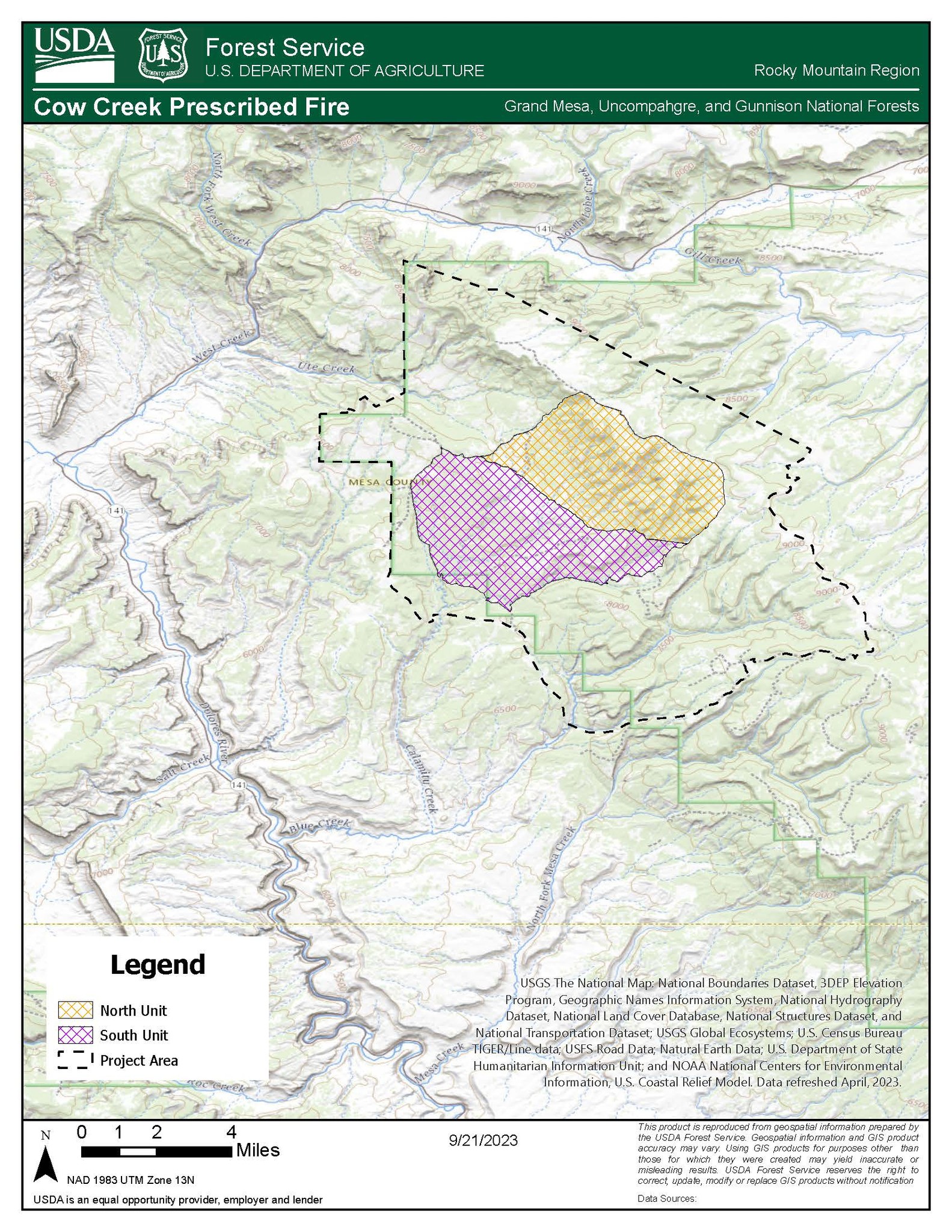
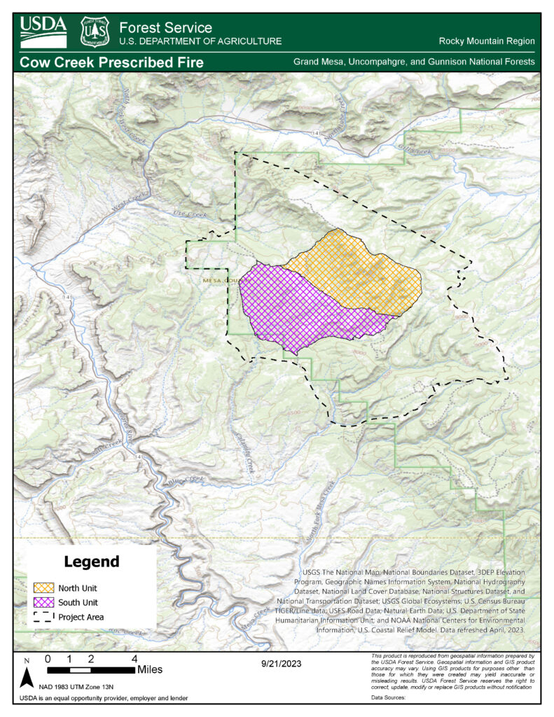
Grand Junction, Colorado, Oct. 6, 2023 – Fire Management Officials from the Grand Mesa, Uncompahgre and Gunnison (GMUG) National Forests’ Grand Valley Ranger District plan to continue prescribed burning operations for the Cow Creek Prescribed Burn. This project area includes Cow Creek, Calamity Creek, and Indian Creek and is approximately 9 miles east of Gateway, Colorado and 25 miles southwest of Grand Junction, Colorado.
During the last week of September, fire personnel were able to successfully treat approximately 5,000 acres of the Cow Creek Prescribed Burn. These acres were primarily in Unit 1 on the northeastern side of the planned burn area. Moving forward, firefighters are now focusing on treating up to an additional 5,000 acres in the Unit 2 area, which is located on the southwestern half of the planned burn area. If conditions allow, firefighters will ignite in the area over multiple days.
Before conducting a prescribed burn, extensive planning establishes proper parameters such as weather, fuel conditions, smoke dispersion, staffing and other agency coordination. Coordinating efforts occur with local landowners, protection partners and other cooperating agencies to ensure that the burn is conducted safely. This prescribed burn will be accomplished using joint-agency fire resources, utilizing both aerial and hand ignitions, and will be closely monitored to ensure that the fire remains within the designated boundaries.
The safety of firefighters and the public are the most important factors considered when planning a prescribed burn. Trained fire managers conduct prescribed burns with a strong understanding of fire behavior and years of on-the-ground experience. These prescribed fire projects will only be implemented when pre-identified firefighting resources are available to support safe operations and specific environmental conditions are met, such as wind speed, fuel moistures, relative humidity, and predictions of smoke dispersion. Fire managers will monitor and staff the fire until it is deemed secure and patrol the prescribed fire until it is declared out.
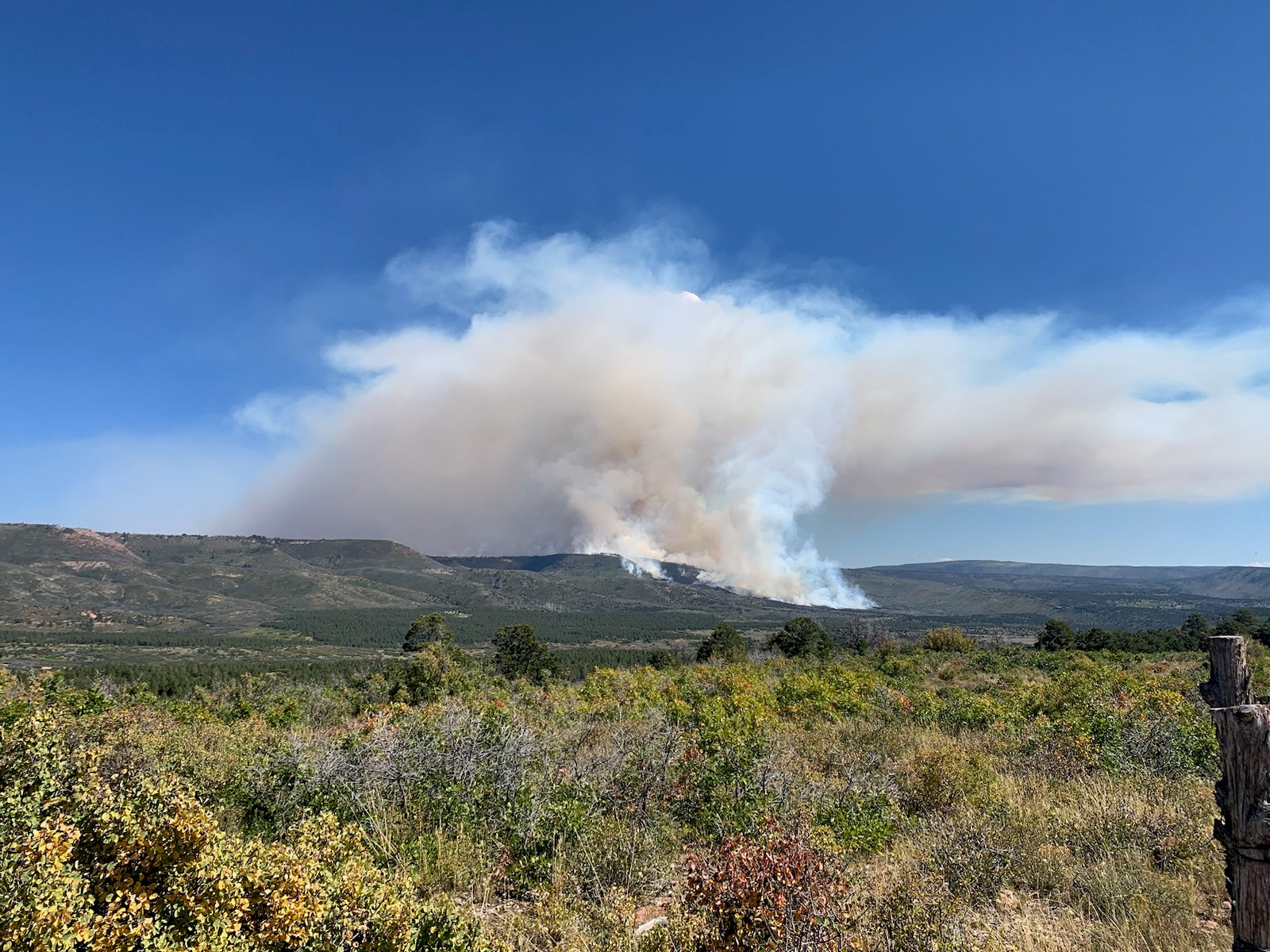
Smoke from the prescribed fire will be managed to have minimal impact on neighboring communities. Fire managers have obtained smoke permits from the State of Colorado and will comply with Colorado State air quality regulations. For more information on how prescribed fire smoke may affect your health, please visit https://www.colorado.gov/pacific/cdphe/wood-smoke-and-health.
Dispersed recreation in the prescribed fire project areas may be impacted. Staff will be making personal contact with recreationists regarding any temporary closures. Signs will be placed on adjacent roads, notifying the public of the project areas, as necessary.
The public is reminded not to call 911 or emergency services if smoke is visible in specific burn areas. Prescribed burn areas and potential dates will be posted on the GMUG Fire Info Facebook page.
Prescribed fire is part of a multi-faceted strategy that helps create stronger fire-adapted ecosystems, which helps reduce the threat of catastrophic wildfire and improves wildlife habitat. By reintroducing fire into the ecosystem, we can promote and regenerate healthy trees and habitat conditions while improving habitat for a variety of wildlife. For more information on prescribed fire as a land management tool, visit https://www.fs.usda.gov/managing-land/prescribed-fire.
For more information on how prescribed burning and pile burning smoke may affect your health, please visit https://www.colorado.gov/pacific/cdphe/wood-smoke-and-health.
For information and updates on current fire restrictions, conditions, and recreation opportunities on the Grand Mesa, Uncompahgre and Gunnison (GMUG) National Forests:
GMUG National Forests Fire Information Hotline: (970) 874-6602
GMUG National Forests website: www.fs.usda.gov/gmug
West Slope Fire Information website: www.WestSlopeFireInfo.com
GMUG Fire Info Facebook: https://www.facebook.com/GMUGFireInfo
Twitter: https://twitter.com/GMUG_NF
—
09/24/23 Update: Firefighters had a successful day on the #CowCreekRX. The conditions allowed them to treat 2500 acres. Operations will continue tomorrow if conditions are good. Smoke will continue to be visible.
—
Due to ideal conditions, ignitions have begun on #CowCreekRX.
The Cow Creek prescribed burn project area is approximately 9 miles east of Gateway, Colorado and 25 miles southwest of Grand Junction, Colorado. The project area includes Cow Creek, Calamity Creek and Indian Creek.
The prescribed burn will be accomplished using joint-agency fire resources utilizing aerial and hand ignitions and will be closely monitored to ensure that they remain within the designated boundaries.
Smoke from the prescribed fire will be managed to have minimal impact on neighboring communities. Smoke may be visible in several communities, including Grand Junction, Whitewater, Gateway, Fruita, Delta, Montrose, and Norwood for multiple days. The public is advised not to call 911.
Prescription (RX) burning is important to maintain a fire adopted eco-system and is essential for wildfire prevention.
https://inciweb.nwcg.gov/…/cogmf-cow-creek-prescribed-burn