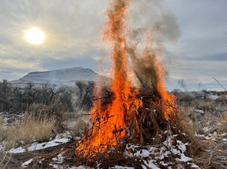
MONTROSE, Colo. – The Bureau of Land Management Southwest District plans to conduct several prescribed burns beginning early September and throughout the fall when conditions allow on public lands managed by the Tres Rios and Uncompahgre Field Offices. These burns are part of larger projects on the Southwest District to reduce hazardous fuels; protect wildland-urban interface communities; improve big game habitat, sage grouse habitat, and range conditions; and reintroduce fire to a fire-adapted ecosystem to restore healthy forests and species diversity.
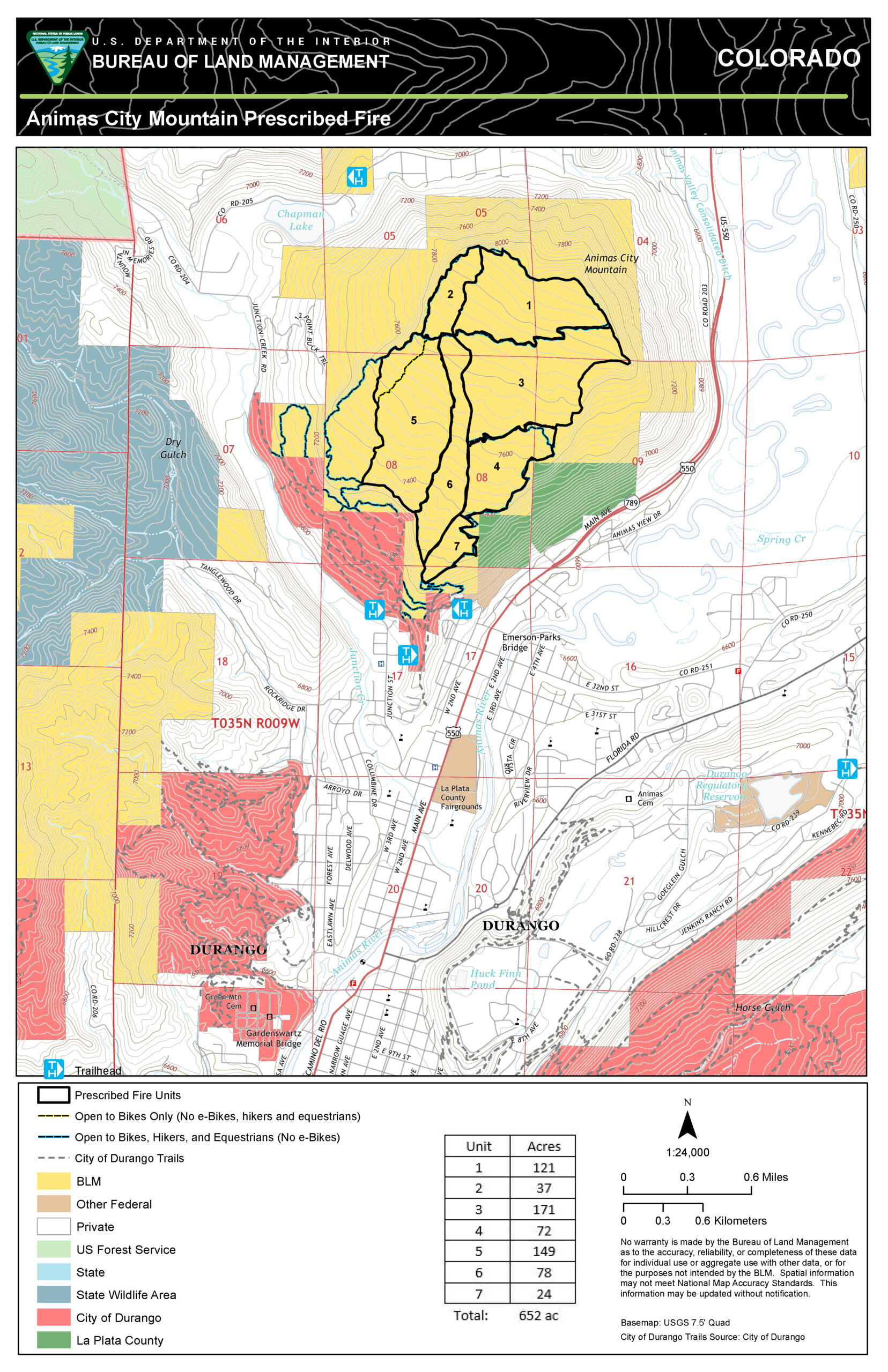
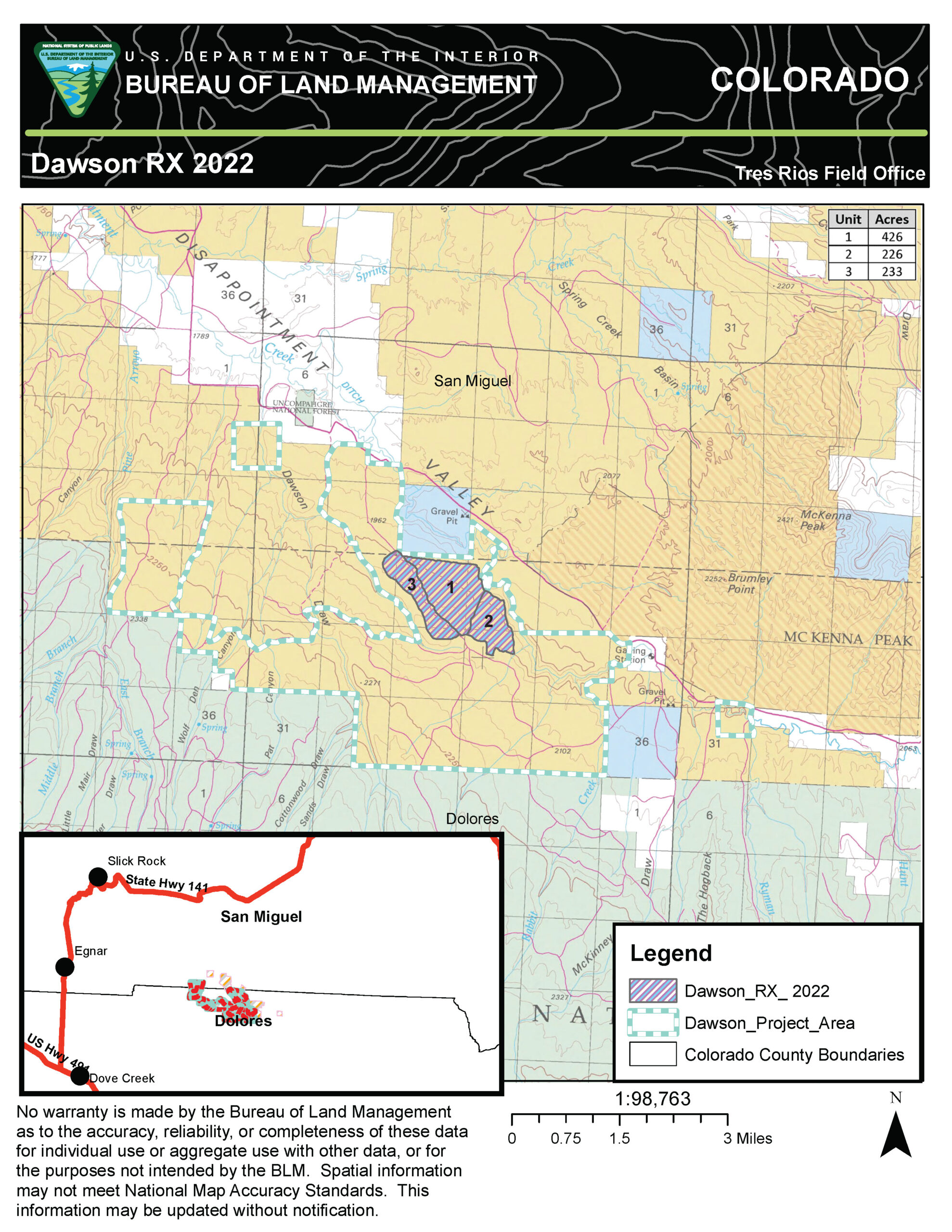
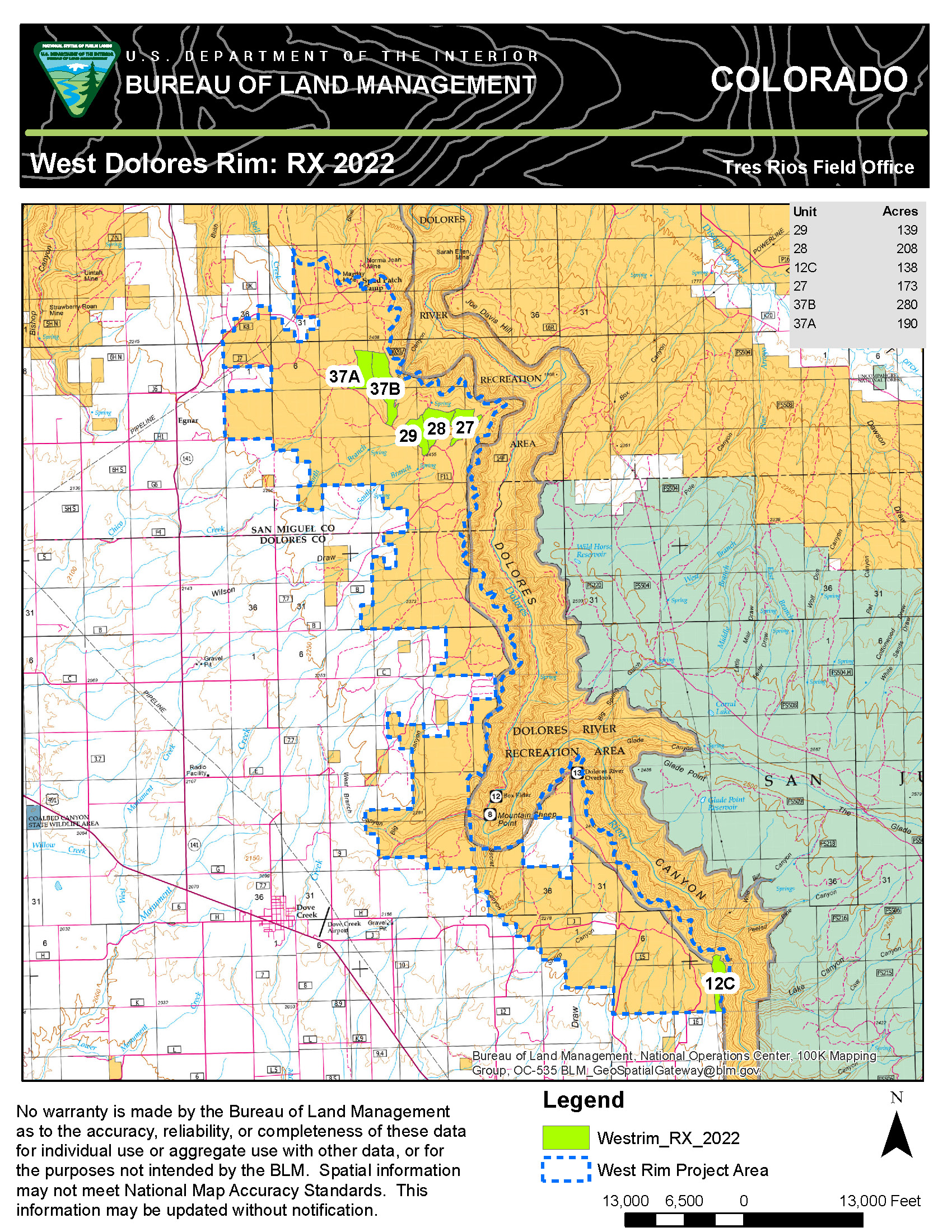
The Tres Rios Field Office plans to burn on Animas City Mountain located within Durango, Dawson Project Area, and the West Dolores Rim Project. On Animas City Mountain, the BLM plans to burn up to 652 acres. To ensure public and firefighter safety during project implementation, there will be a brief closure of the adjacent Animas City Mountain area, including City trailheads/access points. The BLM expects to use designated trails as containment lines. Located 13 miles east-northeast of Dove Creek and 10 miles east of Egnar,the Dawson Project Area prescribed burns will treat up to 883 acres of pinyon, juniper, and mixed mountain shrub and is split between San Miguel and Dolores counties. In addition, crews will continue their ongoing work of treating and burning up to 1,112 acres of ponderosa pine and Gambel oak within the West Dolores Rim Project Area located about seven miles east of Dove Creek, locally referred to as the “East and North Pines.”
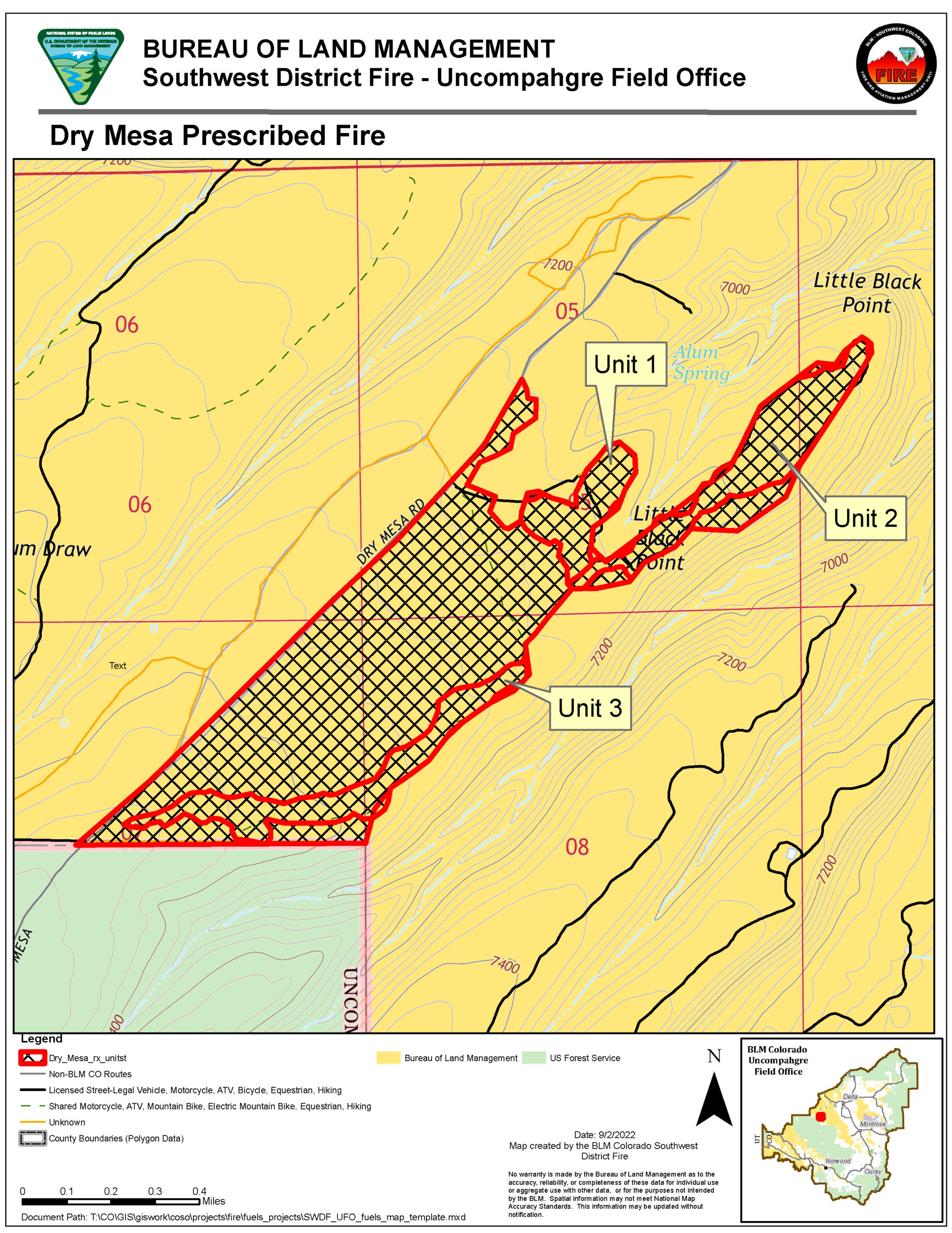
The Uncompahgre Field Office will continue prescribed burning in the Dry Mesa Project Area that will total about 100 acres of sagebrush, dead and down woody debris, pinyon, and juniper. This burn area is approximately 18 miles southwest of Delta, CO in Dominguez-Escalante National Conservation Area.
“The Southwest District has a robust prescribed fire program that seeks to reduce hazardous fuels, improve habitat for wildlife, and protect communities from wildfires. The burns that will be conducted this fall are a part of our efforts to improve ecological conditions and reduce risk to communities throughout the district,” said James Savage, BLM Supervisory Fuels Specialist. Detailed burn plans outline the parameters for each prescribed burn area.
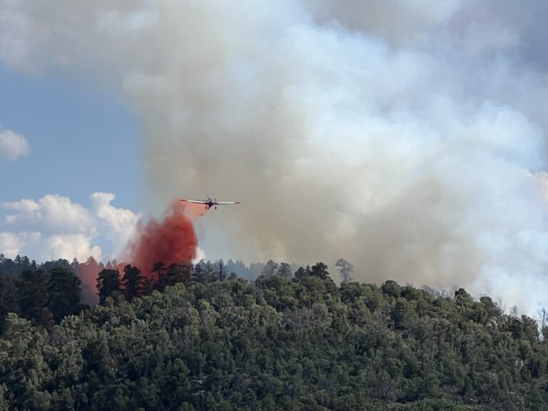
While no road closures are expected during the projects, camping near the units is discouraged due to increased traffic and likelihood of smoke in the area, particularly at night. Multiple days of burning may occur throughout the fall into the winter, as fuel conditions and weather permit. Project areas will be monitored once completed to ensure public safety. While smoke may be visible in the burn area at times, most of the smoke will lift and dissipate during the warmest parts of the day. Expect visible smoke in the area for several days after each burn is completed as vegetation in the interior continues to smolder.
The BLM obtained smoke permits from the Colorado State Air Pollution Control Division, which identify atmospheric conditions under which the burns can be implemented. Prescribed fire smoke may affect your health. For more information, visit https://www.colorado.gov/pacific/cdphe/wood-smoke-and-health.
For information on prescribed burns, visit the Southwest District BLM Prescribed Fire InciWeb pages https://inciweb.nwcg.gov/incident/7852/ or https://inciweb.nwcg.gov/incident/7688/, and follow us on Twitter https://twitter.com/SWD_Fire and Facebook http://www.facebook.com/BLMMontroseFireUnit.
-BLM-
The BLM manages more than 245 million acres of public land located primarily in 12 western states, including Alaska, on behalf of the American people. The BLM also administers 700 million acres of sub-surface mineral estate throughout the nation. Our mission is to sustain the health, diversity, and productivity of America’s public lands for the use and enjoyment of present and future generations.